Stay Curious

SIGN UP FOR OUR WEEKLY NEWSLETTER AND UNLOCK ONE MORE ARTICLE FOR FREE.

Sign Up

VIEW OUR Privacy Policy


Discover Magazine Logo

WANT MORE? KEEP READING FOR AS LOW AS $1.99!

Subscribe

ALREADY A SUBSCRIBER?

FIND MY SUBSCRIPTION
Advertisement

Sizing Up Last Year's Eruption in the Canary Islands

As impressive and destructive as the 2021 eruption on La Palma may have been, it was still a middle-of-the-road volcanic eruption.

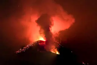
A view of the Cumbre Viejo eruption on La Palma seen on November 11, 2021.Credit: Wikimedia Commons.

Newsletter

Sign up for our email newsletter for the latest science news

Sign Up

One of the most damaging volcanic eruptions from 2021 was the event on La Palma in the Canary Islands. The eruption lasted for months and ended up burying a significant part of the communities that had built up on its slopes. Thankfully, it was an eruption that didn't end up taking lives, but the damage was estimated to be at least $1 billion. As it turns out, the eruption itself compared to others was relatively small, but the human impact was much larger.

A new study in Nature by Riccardo Civico and others has given us high resolution digital elevation models (DEMs) of the La Palma eruption. These models were built from over 12,000 images to create a map that has a resolution of 0.2 millimetres per pixel (below). That's 0.007 inches per pixel, or roughly the size of two sheets of paper stacked together on edge. Now that is ...

Stay Curious

JoinOur List

Sign up for our weekly science updates

View our Privacy Policy

SubscribeTo The Magazine

Save up to 40% off the cover price when you subscribe to Discover magazine.

Subscribe
Advertisement

0 Free Articles