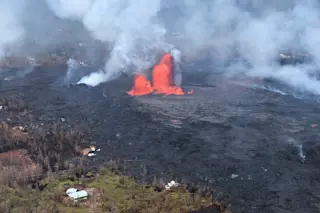
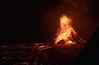
The lava fountain from Fissure 8 seen on May 28, 2018. USGS/HVO. Few things are changing volcano monitoring and hazard planning more than drones. A decade ago, it either took expensive and dangerous helicopter flights or approaching eruptions on foot to get close enough to make observations. Today, we can watch volcanic eruptions and their results up close using relatively cheap drones that can fly into craters and over lava flows to see what's happening. This provides vital data for volcanologists watching the volcano to understand how the eruption is changing. They can also be used to map volcanic deposits and find people who might be in peril due to volcanic activity. Paired with satellite monitoring, drones are making the job of watching volcanic eruptions safer for scientists and citizens. Case in point: The recent events at Kīlauea. Earlier this week, fast moving lava flows from Fissure 8 (see above) ...
How the USGS Used a Drone to Save Someone from Kīlauea's Lava
Discover how Kīlauea lava flows are monitored using drones, enhancing volcanic hazard planning and improving safety for residents.
More on Discover
Stay Curious
SubscribeTo The Magazine
Save up to 40% off the cover price when you subscribe to Discover magazine.
Subscribe

