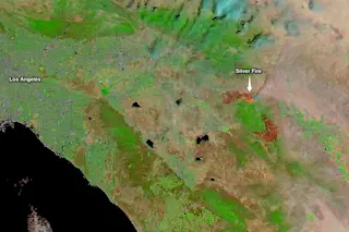
Southern California's Silver Fire as seen in a false color image from NASA's Aqua satellite captured Thursday, Aug. 8. (Image: NASA) | Update 8/9/13 3:15 p.m.: the original version of this post included a Twitpic as the lead graphic. It is no longer loading, so I've moved up the satellite image, redone parts of the post, and included a new Twitpic of the fire below. (See other updates below as well.)| Southern California's Silver Fire ignited on Wednesday and promptly took off, burning through 1,000 acres an hour. It's initial spread through desiccated grass on steep hillsides was so fast that it prompted John Hawkins, the California Department of Forestry and Fire Protection chief in Riverside County, to tell the Los Angeles Times that it was "one of the most rapidly spreading … dangerous fires" that he had seen in 50 years with the agency. The image at the top ...
California Fire: 'One of the Most Rapidly Spreading' in 50 Years
Discover the Southern California Silver Fire, igniting rapidly and creating a significant wildfire risk. See NASA's stunning satellite imagery.
More on Discover
Stay Curious
SubscribeTo The Magazine
Save up to 40% off the cover price when you subscribe to Discover magazine.
Subscribe

