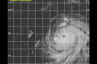
When Hurricane Ioke went out of the range of the Central Pacific Hurricane Center and crossed the International Dateline, the last update said this:
IOKE COULD ENTER THE RECORD BOOKS FOR LONGEVITY AS A CATEGORY 4 OR GREATER STORM.
Now the Joint Typhoon Warning Center, with new responsibility for Supertyphoon Ioke, says this:
THE STORM HAS MAINTAINED SUPER TYPHOON STATUS FOR FIVE CONSECUTIVE DAYS. WITH THE EXCEPTION OF POSSIBLE INTENSITY FLUCTUATIONS DUE TO INTERNAL CONVECTIVE PROCESSES, STY 01C IS FORECAST TO MAINTAIN ITS INTENSITY THROUGH TAU 48 IN THE ABSENCE OF ANY DISRUPTIVE SYNOPTIC INFLUENCES. THE SYSTEM SHOULD WEAKEN SOMEWHAT AFTER TAU 48 AS IT ENCOUNTERS SLIGHTLY LOWER SEA SURFACE TEMPERATURES.
My question for tropical cyclone geeks is, when does Ioke actually break this very significant record, and if/when it does, what storm will it surpass?
Meanwhile Hurricane John is a Category 4 ass kicker in the Eastern North Pacific ...


