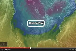
Screenshot from an animation depicting the blast of Arctic air rushing south across much of the U.S. (Images: earth.nullschool.net. Animation: Tom Yulsman) By now you've probably heard enough about the polar vortex to make your head, well, spin. So as the Southeastern United States is being pummeled by a rare winter storm, I thought I'd try to come up with a visualization of the current Arctic blast that's a bit different from what you may have seen already. Click on the image above to watch what I've put together. It's an animation based on visualizations from earth.nullschool.net depicting both the wind field and temperatures over the United States from early in the morning this past Sunday (Jan. 26) through this morning. The moving lines correspond to the winds, and the colors to temperature (with blues, greens, and purples indicating areas that are colder). I am particularly struck by the pattern ...
Visualizing the Latest Arctic Blast
Discover the impact of the Arctic blast winter storm as cold air rushes south across the U.S., reshaping weather patterns.
More on Discover
Stay Curious
SubscribeTo The Magazine
Save up to 40% off the cover price when you subscribe to Discover magazine.
Subscribe

