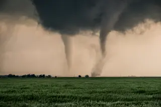
On April 27, 2011, huge storms spawned enormous tornadoes which swept across the southeastern U.S., doing severe damage and killing over 200 people. It was the worst natural disaster in the U.S. since Hurricane Katrina in 2005. The NASA/NOAA Geostationary Operational Environmental Satellite, or GOES, takes high-resolution images every few minutes. The animation below shows the southeast U.S. from GOES, and you can watch the storms erupt.
[embed width="610"]http://www.youtube.com/watch?v=WHLdK8JkqQU[/embed]
A warm, moist air mass from the south collided with a cold air mass over the States. This is how summer storms usually form, but this situation
was amplified by the jet stream, which was blowing between them. This generated fierce local systems that spawned over 150 tornadoes in the course of a single day. It's unclear but unlikely this particular event was due to global warming, but many models indicate such storms will increase in number as the planet warms. ...


