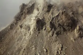
The crumbling lava dome at Paluweh in Indonesia, seen on December 1, 2012. The collapse of a dome such as this may be the cause of the February 2, 2013 explosive eruption at Paluweh. Image: Tom Pfeiffer / Volcano Discovery. Over the weekend, the fairly remote Indonesian volcano Paluweh (also known as Rokatenda) erupted. Now, the size of the eruption is somewhat unclear due to its location on Palu'e Island, north of Flores Island. Early VAAC reports suggested ash as high as 43,000 feet / ~13 km, however reports from on the ground put it closer to 13-16,000 feet / 4-5 km. Now, that is a sizable difference and possibly the early VAAC reports from satellite and aerial observations got the height wrong -- but in any case, the volcano did experience a notable explosive eruption. Ash fell on towns on the nearby island of Flores, with thicknesses in the ...
Pyroclastic Flow Deposits From the Paluweh Eruption
Witness the explosive eruption at Paluweh that followed the dramatic lava dome collapse, revealing stunning pyroclastic flow deposits.
More on Discover
Stay Curious
SubscribeTo The Magazine
Save up to 40% off the cover price when you subscribe to Discover magazine.
Subscribe

