What's Up With 2021's Weather?

From a loopy jet stream to climate change, an in-depth look at the factors that have shaped U.S. weather so far this year.

ImaGeo iconImaGeo
By Tom Yulsman
Apr 17, 2021 8:00 PMApr 17, 2021 8:43 PM
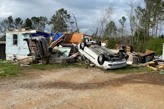
Tornado Damage in Alabama
On March 25, 2021, a family of six managed to survive in a closet of this house as it was torn apart by a tornado in Calhoun County Alabama. (Credit: National Weather Service Birmingham, Alabama via Facebook)

Newsletter

Sign up for our email newsletter for the latest science news
 

On March 25, 11 tornadoes ripped through central Alabama. In a frantic attempt to survive, a family of six huddled in a tiny closet as the largest of the twisters — 1.3 miles wide and with winds shrieking at 150 miles per hour — shredded their home.

Strange as it might seem, these tornados, and an outbreak of more twisters just two days later, were linked to thunderstorms boiling up some 10,000 miles away, over the Indian Ocean. And it wasn't the only U.S. extreme weather event so far this year that was tied to things happening in the atmosphere many thousands of miles away.

Lest you think this is all somehow related to one iteration or another of the famous "butterfly effect" (for example, the question of whether the flap of a butterfly's wings in Brazil can set off a tornado in Texas), no, that's not really it.

Instead of butterflies flapping, think of the myriad instruments playing different parts in a symphony orchestra. This metaphor can help clarify the causes of a number of extreme weather events we've seen this year in the United States.

Mind you, through March, this year hasn't been particularly nasty on average for the U.S. as a whole. According to NOAA, The U.S. Climate Extremes Index was 16 percent below average.

But some regions were hit very hard. For example, there were 284 reports of severe weather across the Southeast during March — 143 percent of the long-term frequency.

Perhaps the most extreme event to occur so far this year in the United States happened in mid-February: the headline-making, deadly Arctic outbreak that sent temperatures plunging to historic lows across much of North America. Below zero wind chills, along with ice and snow cover, extended as far south as northeastern Mexico — a region more accustomed to being whipped by tropical cyclones than blasts of polar air.

The resulting damages in the United States alone amounted to more than $10 billion, making it the nation's most costly winter weather disaster on record, according to a recent report by NOAA.

An intensifying winter storm over the central Rocky Mountains is seen in this image captured by the GOES-16 weather satellite on March 14, 2021. Strong winds along the periphery of the storm kicked up a huge plume of blowing dust, starting in northern Mexico and extending across far southern New Mexico and western/southwestern Texas. (Credit: CIMSS Satellite Blog)

A month later, even as winter was transitioning to spring, a slow-moving storm packing huge amounts of moisture plastered parts of Colorado and southern Wyoming. Snowfall up to four feet was reported in parts of Colorado and Wyoming. (To the east, where it was warmer, two to six inches of rain occurred across portions of Kansas and Nebraska.)

In Cheyenne, Wyoming, drifts as high as six feet were reported. For Denver, the blizzard's 27.1 inches of white stuff qualified it as the second snowiest March storm on record, and the fourth biggest overall.

Just three days later, a vicious tornado outbreak struck the South. And then it happened again between March 25th and 27th. The violent EF3-tornado that struck Calhoun County, Alabama, was one of these, causing five deaths, according to NOAA's report.

Luckily, the Alabama family huddling in the closet was not among them.

Seeking an explanation for what was going on, and thinking it might all be tied somehow to the La Niña climate phenomenon, I got in touch with Victor Gensini, an expert in climate and severe weather at Northern Illinois University. Among other things, I learned that while La Niña probably has been exerting an influence on our weather, other factors appeared to be even more important.

And it was Gensini who urged me to think of the atmosphere as a symphony orchestra. Or, as he put it, "an ensemble of instruments, and sometimes, some of those instruments are playing more loudly than others."

Among the instruments playing loudly early in the year was a phenomnon known as the Arctic Oscillation. The AO tends to favor exagerrated waviness in the polar jet stream — a fast-moving atmospheric river that normally helps sweep weather systems along.

Another is a wave-like phenomenon called the Madden-Julian Oscillation. It is the MJO, in fact, that links those Indian Ocean thunderstorms to twisters in the U.S. South.

And then there's an instrument that has been playing with increasing prominence over the years: human-caused climate change.

Let's go through some of this year's extreme events chronologically, starting with the historic Arctic outbreak in February.

The Arctic Comes to Mexico

To understand how northeastern Mexico, with its subtropical climate, could experience snow and ice, you have to look about 4,000 miles to the north, and 10 to 30 miles up in the atmosphere. Here you'll find the now notorious polar vortex.

This river of air girdling the high Arctic in the stratosphere usually flows fast and strong in winter, helping to bottle up the worst of the Arctic cold. But in January and early February, the flow of the vortex weakened significantly and got stretched out of shape.

This can happen when that Arctic Oscillation — a seesawing pattern of air pressure and atmospheric circulation anomalies — dips into what scientists call its negative mode. For our purposes, the nitty gritty details aren't crucial. Suffice it to say that at the beginning of February, the AO was playing quite loudly in that negative mode.

Two weeks later, this had an effect that many forecasters expected: The polar jet stream, which flows at a lower level in the atmosphere than the vortex, also became weakened, and instead of flowing fast and straight, it became very wavy. That, in turn, pushed the door to the wintertime Arctic wide open, allowing frigid air to spill far south.

You can see this in the similation above. The white lines trace out the deeply wavy path of the polar jet stream on February 15, 2021, and the cooler and darker colors indicate colder temperatures. (Pinks are warmer.)

The cold Arctic air ultimately spilled across Canada, through the Upper Midwest (where it caused temperatures in Ely, Minnesota to plummet to -50 degrees F), down into Texas (where it caused widespread power outages and bursting of water pipes), and ultimately across the border into Mexico.

La Niña's Part in the Symphony

At the time, the Arctic Oscillation wasn't the only instrument with a prominent part to play in the atmospheric symphony. Another was La Niña.

But curiously, it didn't follow the score in quite the way that experts like Gensini had expected.

In contrast to El Niño, her hotter brother, La Niña plays it really cool — literally so. The climatic phenomenon is characterized by unusually chilly surface waters in the equatorial Pacific, along with a cascade of related effects in the atmosphere above.

Some of those effects extend far afield — all the way from the equator in the middle of the Pacific Ocean to the more temperate latitudes across North America. And La Niña does this in a way that's similar to the Arctic Oscillation: by favoring a more wavy flow in the polar jet stream. At the same time, it can also favor a northward shift in the jet overall.

But what has happened to the jet stream during this La Niña actually has been "a lot different than in the past," Gensini says. "It looks a lot more like climate change."

For much of the early part of 2021, the polar jet stream has shifted farther north than forecasters have come to expect during a La Niña — to an average of 60 degrees north latitude, according to Gensini. (That's only about 400 miles south of the Arctic Circle.) As a result, the polar jet stream has had much less interaction with its own sibling, the subtropical jet, which flows farther south.

The Northern Hemisphere typically features two fast-moving rivers of air, a southernly sub-tropical jet stream and a northerly polar jet. The approximate position of both on April 9, 2021 is marked in yellow in this image showing air flow at about six to nine miles high in the atmosphere. So far this year, the flow has been significantly split, with the polar jet circulating farther north than usual. (Credit: Image from earth.nullschool.net with annotation by Tom Yulsman)

This "split flow" pattern, with the two jet streams widely spaced and interacting very little, can allow a winter storm system to get cut off from the flow of the jet streams, causing it to move very slowly, all the while sucking in lots of moisture from the south.

And that's exactly what happened during the big Colorado and Wyoming snow storm in March.

La Niña often favors a split flow pattern of jet streams, "but not this persistent," Gensini says. By this time of year, the two jet streams are tending to overlap and interact a lot. "But we're seeing very little of that this year. That's not very typical of La Niña."

This is what leads Gensini to suspect that another instrument is playing a particularly enhanced role in this year's atmospheric sympthony: climate change.

The jet streams are driven by the huge temperature difference between the warm tropics and the frigid poles. But as the Arctic has warmed faster than the rest of the globe, that temperature gradient has weakened. Both physics and climate modeling suggest that this can make the jet streams somewhat enfeebled. But not just that: the polar jet should also shift north, according to Gensini.

He cautions that it's "really hard for us to look at what’s happening and say, 'yup it’s climate change.' But it is consistent with what our climate models tell us we should expect from climate change." 

Tornadic Terror

Relative to other instruments, La Niña has been playing a little less loudly than expected in another way too.

Research shows that La Niña years tend to bring increased tornaodo activity in the southern United States. That's precisely why forecasters were expecting an upsurge in twisters there this year.

But the orchestra has had something a little more, well, atonal in mind: March's extreme activity has actually been the exception, not the rule — at least so far.

"The above average forecast has not panned out yet," Gensini says. January and February were actually quieter than normal, with fewer than 10 tornados through March 1."

But after a quiet first week of the month, tornados roared to life.

A tornado ripped apart this home in Alabama when it rampaged through the area on March 25, 2021. (Credit: National Weather Service Birmingham, Alabama)

According to statistics compiled by NOAA's Storm Prediction Center, March brought more than double the average number of tornadoes for the month: 173 vs the 1989-2013 average of 78.

"That puts the annual count of tornadoes where it's supposed be," Gensini says. In other words, at about an average number through the end of March.

La Niña may have played a part in the upsurge. But the loudest player in early March was probably the Madden-Julian oscillation — which seems to have tipped the scales (ahem) toward enhanced tornadic activity. How?

That's where that cluster of thunderstorms boiling up in the Indian Ocean comes in. As part of the MJO cycle, this area of clouds, rainfall, and winds moves eastward, eventually traversing the planet in the tropics and returning to where it all started in 30 to 60 days, on average. And a long the way, it can have far-reaching impacts on weather elsewhere.

The MJO cycle starts with enhanced thunderstorm activity over the Indian Ocean. Here, air rises and then spreads out high in the atmosphere. Ahead of this convection is an area of suppressed activity, centered over the west-central Pacific Ocean. Here, winds sink and warm, then spread out at the surface, inhibiting rainfall. The entire system shifts eastward over time, eventually circling the globe and returning to its point of origin. (Credit: Climate.gov drawing by Fiona Martin.)

To understand how the MJO influenced the tornado outbreaks in March, let's put aside the symphonic metaphor for a moment, and think of the atmosphere as a liquid. In fact, from the point of view of physics, "it behaves just like water does," Gensini says. That's important because something that disturbs the atmosphere in one place can cause waves of disruption to flow thousands of miles around the globe.

And that's exactly what happens with the MJO. "Imagine a pool," Gensini says. "Someone is bouncing up and down in it on a raft, sending out waves." That's what the thunderstorms in the Indian Ocean do.

In the atmosphere, these "Rossby waves" propagate to the east, eventually reaching North America about two weeks later. And once here, they can favor extreme weather. (They can also do the opposite, depending on the circumstances.) 

In early March, La Niña was ongoing but not having the expected influence on tornado activity. Then, however, that proverbial MJO raft out in the Indian Ocean began bouncing up and down, sending out Rossby waves.

With all that in mind, forecasters warned that weather conditions two weeks hence were likely to bring twisters and hail to parts of the U.S. South. And as we've seen, that's precisely what happened.

"There are times when weather is very predictable, and other times when its not," Gensini says. "These MJO events allow us to harness extra predictability."

Now, it will be helpful to return to our original metaphor...

Back to the Symphony

As of the first week of April, the MJO was playing in a way that heralded a lull in intense tornado activity for a spell. That's the good news.

But the rest of April, through May and into early June, is the period when tornado activity typically peaks in the southern United States. And even though La Niña now appears to be fading, its influence is still likely to be heard.

"We do expect La Niña to favor increased tornado activity," Gensini says.

Forecasters will be much surer when the MJO begins playing loudly again. But of course by that point, other members of the atmospheric orchestra may be chagning the score.

1 free article left
Want More? Get unlimited access for as low as $1.99/month

Already a subscriber?

Register or Log In

1 free articleSubscribe
Discover Magazine Logo
Want more?

Keep reading for as low as $1.99!

Subscribe

Already a subscriber?

Register or Log In

More From Discover
Recommendations From Our Store
Shop Now
Stay Curious
Join
Our List

Sign up for our weekly science updates.

 
Subscribe
To The Magazine

Save up to 40% off the cover price when you subscribe to Discover magazine.

Copyright © 2024 Kalmbach Media Co.