Trees ripped out of the ground, cars tossed in the air, and homes shredded into splinters — the aftermath of a tornado can be a frightening sight to behold from the ground.
But what about from space? Is it possible to see a tornado’s path of destruction in satellite imagery?
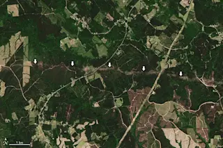
As the Landsat 8 satellite image above shows, the answer is yes. That somewhat-uneven line marked by arrows is the path of a tornado spawned by a supercell storm system that churned across nearly 300 miles of the Southern U.S. on April 22 and 23, 2020.
The trail of damage visible in the image was caused by an EF-2 tornado that cut through Jasper and Newton counties in Texas, with peak winds of 130 mph. It damaged roofs and snapped trees along a 37-mile-long track.
“While this tornado passed through a rural area and caused no injuries, the same supercell ...


