Science Meets Art: Stunning Satellite Imagery Reveals Massive Asian Dust Storm

The late March dust storm occurred when strong winds lofted a vast blanket of dust over the Gobi Desert and blew it into eastern China.

ImaGeo iconImaGeo
By Tom Yulsman
Mar 27, 2023 11:30 PMMar 27, 2023 11:31 PM
Asian Dust Storm
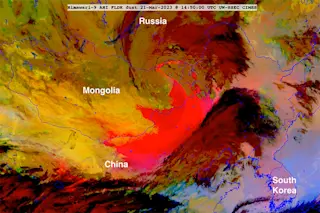
A massive dust storm over Mongolia and China is revealed in magenta tones in this screenshot from a timelapse animation of Himawari-9 satellite imagery acquired on March 21, 2023. Please see below for the timelapse itself. (Credit: CIMSS Satellite Blog)

Newsletter

Sign up for our email newsletter for the latest science news
 

Were it not for the labels and national borders, the image above might easily be mistaken for an abstract expressionist painting. But it is, in fact, a satellite image that reveals a sprawling dust storm over Asia.

The storm arose as tightly juxtaposed areas of high and low atmospheric pressure generated strong winds that lofted massive amounts of dust over Mongolia. The comma-shaped low-pressure system then whisked the dust all the way into northeastern China. In the image above, and the timelapse animation below, the dust shows up in shades of bright magenta and pink.

As the dust storm moved into eastern China on March 22, visibility plummeted in Beijing, and air quality sensors there revealed soaring levels of particulate matter. In total, the dust affected more than 560 million people.

The luminescent colors and swirling patterns in the satellite views demonstrate how imagery at the intersection of science and art can provide beautiful and revealing perspectives on atmospheric events. An example of what's known as dust RGB imagery, the false-color views were created using different wavelengths of infrared light to distinguish airborne dust from clouds during both day and nighttime.

“I think of RGBs as a place where science meets art,” says Steven Miller, senior research scientist at the Cooperative Institute for Research in the Atmosphere. The colors are visually compelling and at the same time maximize information content about a complex scene in a way that meteorologists can quickly interpret. "For the RGB to be most useful, it must clearly communicate multiple features unambiguously within a single display," Miller explains.

Here's the dust storm as visualized using visible wavelengths of light:

An animation of true-color Himawari-9 satellite imagery reveals massive amounts of dust being entrained in a comma-shaped low pressure system over Northern China in late March of 2023. (Credit: RAMMB-CIRA Satellite Library)

The evolution of the comma-shaped low-pressure system, and the dust it is sweeping across a vast region, is clearly evident. Even so, the Dust RGB imagery conveys more information about what's going on in the atmosphere.

More From Discover
Recommendations From Our Store
Shop Now
Stay Curious
Join
Our List

Sign up for our weekly science updates.

 
Subscribe
To The Magazine

Save up to 40% off the cover price when you subscribe to Discover magazine.

Copyright © 2024 Kalmbach Media Co.