Stay Curious

SIGN UP FOR OUR WEEKLY NEWSLETTER AND UNLOCK ONE MORE ARTICLE FOR FREE.

Sign Up

VIEW OUR Privacy Policy


Discover Magazine Logo

WANT MORE? KEEP READING FOR AS LOW AS $1.99!

Subscribe

ALREADY A SUBSCRIBER?

FIND MY SUBSCRIPTION
Advertisement

Satellite Views Reveal the Brutal Arctic Outbreak in All Its Meteorological Wildness

You've probably seen what the weather models thought it would look like. Now, here's how it has really appeared, as seen from space.

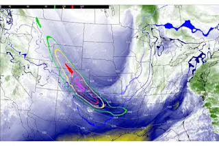
A screenshot of an animation of GOES-16 satellite imagery showing the outbreak of brutally cold Arctic air across North America on Dec. 21 and 22. See below for the animation, along with a detailed explanation of the features seen in this image.Credit: Satellite Liaison Blog

Newsletter

Sign up for our email newsletter for the latest science news

Sign Up

As savage Arctic cold was getting ready to surge south across North America, vivid imagery based on data from weather models showed us what was going to happen. Now, views from space are showing us what actually happened — and the imagery is no less compelling.

As predicted by the models, the jet stream took a giant southward dip on Dec. 21, opening the door to the Arctic and allowing savagely cold air to surge all the way down to the Gulf of Mexico. As this unfolded, a potent storm system exploded, tapping into energy in the jet stream and the stark contrast between temperatures on either either side of the cold front. Worst hit was the Buffalo, N.Y. region, which was buried in places by 50 inches of snow and where, sadly, at least 28 people have lost their lives.

Distortion of the stratospheric polar vortex heralded the coming ...

Stay Curious

JoinOur List

Sign up for our weekly science updates

View our Privacy Policy

SubscribeTo The Magazine

Save up to 40% off the cover price when you subscribe to Discover magazine.

Subscribe
Advertisement

0 Free Articles