Stay Curious

SIGN UP FOR OUR WEEKLY NEWSLETTER AND UNLOCK ONE MORE ARTICLE FOR FREE.

Sign Up

VIEW OUR Privacy Policy


Discover Magazine Logo

WANT MORE? KEEP READING FOR AS LOW AS $1.99!

Subscribe

ALREADY A SUBSCRIBER?

FIND MY SUBSCRIPTION
Advertisement

Iowa Tornado's Path of Destruction as Seen From Space

Thanks to clashing air masses and a jet stream sweeping storms along between them, this spring has brought a rash of destructive tornadoes.

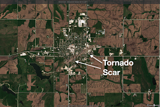
An EF-4 tornado carved a path of destruction through Greenfield, Iowa, on May 21, 2024. With peak winds of 185 miles per hour, the twister's rampage through the little town is visible in this image captured by the Sentinel 2 satellite on May 25.Credit: Modified Copernicus Sentinel data processed by Tom Yulsman

Newsletter

Sign up for our email newsletter for the latest science news

Sign Up

It has been quite a spring for twisters in the United States. So far this year, the preliminary tally from the Storm Prediction Center has reached 1,035 tornadoes, with 872 of them occurring in April and May.

And we've still got another peak month of activity left to go.

One of the most destructive of this season's tornadoes spun up on Tuesday, May 21 in southwestern Iowa. It then carved a destructive 44-mile path to the northeast, ultimately rampaging through tiny Greenfield, population 2,062. Spinning at 185 miles per hour, the EF-4 twister reached a terrifying maximum extent of more than a half mile wide.

Tragically, it killed five people in Greenfield.

The gash it cut through the town is seen in the satellite image above, and also in this one released by NASA today:

The path of destruction across Greenfield, Iowa is visible in this image, acquired on May ...

Stay Curious

JoinOur List

Sign up for our weekly science updates

View our Privacy Policy

SubscribeTo The Magazine

Save up to 40% off the cover price when you subscribe to Discover magazine.

Subscribe
Advertisement

0 Free Articles