This story was originally published in our May/June 2022 issue as "Ahead of the Storm." Click here to subscribe to read more stories like this one.
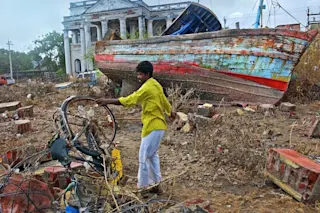
After the 2004 tsunami struck India, then-14-year-old Rohini Sampoornam Swaminathan visited several affected villages with her father.
She noticed a deafening silence and a sense of hopelessness in areas once abuzz with fishing activity. People had lost their homes and loved ones. Fishing boats, the sole income source for many, had washed away or been completely destroyed. And she met a man who pointed to a mass grave containing hundreds of people — he told her there wasn’t enough time to dig individual plots.
Still mulling over the devastation, she huddled inside an internet café to find out why natural disasters happen. She stumbled upon geoinformatics, the science of mapping and remote sensing, and learned how it can help communities prepare for life-threatening disasters.
Swaminathan is now an emergency specialist at UNICEF’s Risk Analysis and Preparedness division. There, she uses geospatial technology to forecast natural disasters around the world, along with mapping and monitoring other crises like epidemics and political conflicts.
As climate change escalates storms and other dangers, work like Swaminathan’s will be key to saving lives: Only when we know where disasters happen can emergency workers plan their response and recovery efforts quickly and efficiently.
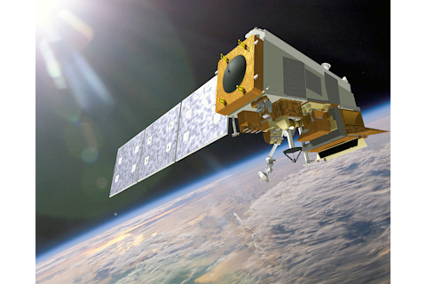
NASA's NOAA-20 satellite is used to track disasters all over the globe. (Credit: NASA)
NASA
Q: What made you choose to work in geomatics — and what exactly is it?
RS: I have always been interested in geography. But what really influenced me were natural hazards, especially the Indian Ocean tsunami that happened when I was around 14.
My dad used to visit fishing villages as part of his job with the [South Indian] state of Tamil Nadu, in their fisheries department. I would often go with him because the Tamil Nadu coast is so beautiful. A few weeks after the tsunami, we went back and I saw what natural disasters were for the first time. We had experienced cyclones living close to the coast. But none of it was like the tsunami.
Later, I learnt that something as simple as loudspeakers to warn people of giant waves probably could have saved thousands of lives. Once I learnt about geomatics and how its applications are used to respond to natural hazards and also prepare people, that became the biggest motivation for me.
Q: What are you currently working on?
RS: I scan situations around the world and pinpoint where there could be emerging risks or deterioration in existing situations, like natural hazards, conflicts, epidemics or pandemics — any sort of risk that can affect children in those countries. I do this by using global models, news, and with the help of our regional country offices. We are in the process of developing an interactive online dashboard to identify potential threats.
Q: Technology-wise, where is your field compared to a few decades ago?
RS: Satellite remote sensing has given us a power that we didn’t have before. Not just in early warning, but it’s an efficient way to know the extent of damage when something happens.
For massive disasters like the 2015 Nepal earthquake, the first 72 hours are the most crucial to save the maximum number of lives. But when it strikes a village in the mountains and there’s no telecommunications working, satellite imagery quickly shows which places are affected. After an earthquake, landslides are very common. So, we need to know if a truck carrying supplies can reach the village or not. Are the roads still functional? Is the bridge still standing? Responders need this information, but they can’t get that on the ground.
There is a global consortium called the International Charter Space and Major Disasters, which can be activated for natural hazards no matter where it happens, and all the countries pitch in for free. Whichever country’s satellite is passing by, they take the image, so we have more information. And this has really aided our response because satellite imagery is really expensive otherwise.
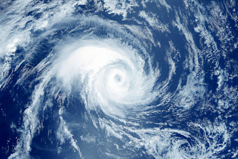
Satellite imagery helps scientists determine the strength and path of hurricanes, and can allow for timely evacuation of affected communities. (Credit: think4photop/Shutterstock)
think4photop/Shutterstock
Q: Can you explain how geomatics helps people at the community level?
RS: Early-warning systems have made a huge difference internationally.
When I was little, we wouldn’t know when a cyclone was coming until a few hours before it hit. Now we have models that can semi-accurately predict the trajectory seven days before the cyclone hits. So that gives plenty of time for us to respond. We in UNICEF have been advocating for risk analysis and better early warning to prepare for disasters. And we do this by integrating different data sources, including weather, disease and population data, into a format where people can make sense of it.
Somalia is a good example of this. We bring all the information into one platform and spatially display it across the country. That helps us see which regions might be most prone to specific hazards like floods, droughts, and even cyclones, though [they are] rare. We need to know where it can happen.
And it’s not just looking at the hazards. In the second step, we find out how many people live there. We have a lot of global data sets that quite accurately estimate population.
And the third important thing to know is how vulnerable these people are: how many children there are, poverty or malnutrition rates, any vulnerability risk that can compound the already existing exposure.
By combining these three — hazard, vulnerability, exposure — we can tell where the risks are and see how to help the people living there. I think bringing this spatial information and non-spatial data from the ground is such a powerful tool to enable decision-making at a higher level.
Q: How does this work help with hurricanes around the globe?
RS: It’s very important to understand when hurricanes and floods happen. Together, they are some of the most dreadful disasters that affect human lives. We work with regional agencies, who play a huge factor in preparing for hurricanes.
For example, UNICEF partners with the Caribbean Disaster Emergency Management Agency on a joint preparedness and response, since they would already be doing these things at a basic level and we want to avoid duplication of efforts.
We have a seasonal hazard calendar for each country UNICEF works with, and we target hurricanes and tropical cyclones a lot. Before the season starts, scientists from the World Meteorological Organization and other research institutions run global models and tell us how bad it is going to be. In 2021, we learned a few months ahead that it would be an above-average Atlantic hurricane season, with three to five Level 3 cyclones. Once we have that information, we meet with government agencies to identify how we can prepare. At UNICEF, we fund some preventive activities to enable people to pre-position supplies or do some capacity building on how to respond. It makes a world of difference to be prepared for hazards that happen regularly.
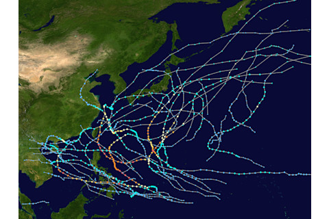
Last year brought a below-average Pacific typhoon season, mapped above. But the final storm, Super Typhoon Rai, hit land with 160 mph winds and ravaged the Philippines. (Credit: MEOW/wikimedia commons)
MEOW/wikimedia commons
Q: As climate change continues to worsen natural disasters, how can we improve preparedness?
RS: Scientific developments have enabled us to better understand natural hazards in more detail than ever. We have sophisticated global models for cyclones, earthquakes and hurricanes that provide us with reliable early-warning information in most places.
For example, for tropical storms, we use multiple sources such as alerts from the Joint Typhoon Warning Center, a collaboration between the U.S. Navy and Army, along with NOAA [National Oceanic and Atmospheric Administration] weather reports.
But the main problem is twofold: One is communicating this information to the people living in that hazard zone. It has to go through multiple loops, providing their national or local disaster-management authorities with this information. The second is understanding vulnerability factors at a regional level, such as poverty and child marriage. So the whole arena of things needs to improve.
We have come a long way in preparedness. But almost everywhere in the world, preparedness does not get the same level of enthusiasm as disaster response. We do more after something happens. That needs to change.
People have realized how much money we can save in response if we invest in preparedness. But this impression has not been transferred reliably. One reason is human psychology, and also we have so many pressing needs, it’s hard to justify preparing for something that will possibly happen.
Q: You worked as a United Nations volunteer supporting developmental projects. How does that experience tie into your geomatics work?
RS: I volunteer with the U.N. Development Program using satellite-based monitoring to support their development projects across the world. For example, if UNDP built a school or a hospital, I would remotely monitor the progress and also check if the building is still standing in case a conflict broke out.
I have been fortunate enough to go to several countries, including South Sudan, Afghanistan and Djibouti, through my work with different U.N. agencies. This has helped me understand how people’s needs vary in different contexts with different hazards.
Whenever I can, I also volunteer with other non-governmental organizations as it gives a different dimension to my work. Otherwise there is a disconnect between working in the headquarters and where people actually are. I worked with a grassroots NGO in Turkey and some of my favorite moments came from working with Syrian and other refugees who were trying to pass through Turkey to get to Greece. The refugees would take the boat to cross, and many people would actually lose their lives during this perilous journey. We would start mapping the refugee camps to identify how many people are where, and also help route their food supplies and get them medical help.
Q: What are your biggest career achievements?
RS: I feel most proud of my work when I give talks to students. Especially here in India, many girls can relate to me as I look like them. People write to me saying they never thought that a girl from rural India could do all these things. But it doesn’t take a genius, it just takes motivation and the right opportunities. When I share this, it makes a huge impact on the students.
The second thing is that women are largely underrepresented in this field, especially women of color. I sit at the executive board of a professional network called Women in Geospatial, where we are trying to promote women across the world to take up more space in this technology.
Q: Has the pandemic highlighted the field of emergency management?
RS: I think the pandemic has had a huge impact on the general public in understanding the need for preparedness.
In recent years in India, I’ve seen videos in local languages played in schools on how to prepare for a cyclone. Several emerging countries have done extensive work in improving their early-warning systems, their preparedness measures and also understanding how quickly we can respond. I think in the new way of living post-pandemic, as long as this is in memory, we will be using this experience in mainstreaming emergency preparedness and understanding risk. The pandemic has accelerated the option of disaster risk-reduction policies in more countries than not.
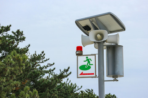
Japan uses siren systems to alert people to oncoming tsunamis. (Credit: PATARA/Shutterstock)
PATARA/Shutterstock
How the World Prepares for the Worst
Early-warning systems, which notify people of incoming natural disasters, are highly demanding. They require monitoring and forecasting risky events, distributing alerts and preparing local responses. But the benefits far outweigh the drawbacks.
Roughly half of all countries currently use such systems. They incorporate sophisticated climate models that include atmospheric and oceanic data sourced from satellites, such as temperature, wind speed and rainfall.
In the U.S., National Oceanic and Atmospheric Administration scientists conduct real-time radar observations of hurricanes using satellite data and measurements like wind shear, humidity and momentum. They feed these figures into forecast-generating models. The National Hurricane Center can therefore issue forecasts for hurricanes at both 96 hours and 120 hours prior to landfall. In the late 20th century, forecasting measures prevented 66 to 90 percent of U.S. hurricane-related deaths that would’ve occurred without such methods, according to a 2007 Natural Hazards Review study.
Recent innovations are even better suited to save lives: Weather monitoring has progressed significantly since the first weather satellites were launched in the 1960s. Over the past two decades, U.S. forecasting abilities have benefited from high-resolution Earth-observing satellites that measure atmospheric and ocean changes.
But not all nations have been able to employ these life-saving technologies. Just before the 2004 tsunami hit South Asia, the Pacific Tsunami Warning Centre in Hawaii picked up the preceding earthquake. But officials couldn’t spread warnings widely because most of the affected nations lacked sufficient communication and emergency response systems.
To bridge that gap, the United Nations has conducted disaster-management training programs with developing nations’ governments since the 1990s. These programs instruct officials on the use of geospatial technology to map and estimate the risks of various hazards, including floods, droughts and earthquakes. Additionally, experts like Rohini Sampoornam Swaminathan have helped monitor such events and disseminate alerts to impacted countries.
They begin by scanning through weather data and discussing three-month forecasts with fellow U.N. agencies and other partners. Swaminathan and her colleagues focus on seasonal threats like hurricanes and monsoons.
When a hazard approaches, the U.N. sends alerts through subscriber emails and social media. With hurricanes and cyclones, they usually circulate warnings up to seven days beforehand. “Floods are a bit trickier,” Swaminathan says: Reliable global models to predict flash and coastal floods are lacking.
Next, U.N. offices around the globe coordinate with local governments. A given country’s U.N. coordinator may convene a disaster relief team composed of U.N. agencies, various non- governmental organizations and the Red Cross.
Specific disasters require additional support; in the case of earthquakes, for instance, the U.N. deploys rescue squads. After the November 2019 Albania earthquake, the U.N. assisted around 20,000 survivors.
Despite ramped-up monitoring and warning efforts, climate change has complicated forecasting due to shifting weather patterns. For one, warming temperatures may continue to worsen tropical cyclones just before they hit land, surprising civilians and forecasters alike. It will be up to specialists like Swaminathan to navigate an increasingly unpredictable climate.


