How Mapping the Seafloor Benefits Science and Safety

Learn more about this seafloor mapping initiative and how having a clear understanding of seafloors can help in ecological and economic safety.

By Emilie Le Beau Lucchesi
Jan 13, 2025 4:00 PM
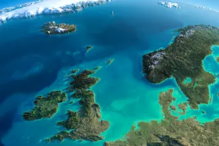
topograhical-map-of-islands-and-ocean
(Credit:Anton Balazh/Shutterstock)

Newsletter

Sign up for our email newsletter for the latest science news
 

In recent years, the Great Lakes have been subject to some wild rumors, including the claim that a mysterious force, the supposed Great Lakes Triangle, was responsible for ships vanishing. Scientists countered that most shipwrecks actually occurred outside of the fictional triangle and were accounted for in a database.

Such spooktacular stories may soon be put to rest. In 2019, the U.S. began a seafloor mapping initiative that included the Great Lakes. The project should be able to take note of sunken vessels or other objects resting on the lakebed.

The seafloor mapping initiative involves all U.S. coastlines, including those as far as Alaska or remote Pacific islands. Scientists working with the project say it will help make navigation safer and has the potential to protect marine habitats and heritage sites. 


0 free articles left
Want More? Get unlimited access for as low as $1.99/month

Already a subscriber?

Register or Log In

0 free articlesSubscribe
Discover Magazine Logo
Want more?

Keep reading for as low as $1.99!

Subscribe

Already a subscriber?

Register or Log In

Stay Curious

Sign up for our weekly newsletter and unlock one more article for free.


View our Privacy Policy


Want more?
Keep reading for as low as $1.99!


Log In or Register

Already a subscriber?
Find my Subscription

More From Discover
Stay Curious
Join
Our List

Sign up for our weekly science updates.

 
Subscribe
To The Magazine

Save up to 40% off the cover price when you subscribe to Discover magazine.

Copyright © 2025 LabX Media Group