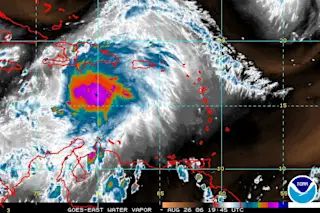
Above is the latest water vapor image for Ernesto, which now has a central pressure that's dropped to 997 mb and sustained winds that are nearing 60 mph. In short, it looks like this is going to be a Category 1 hurricane soon, our first of the season. And the projected track continues to look scary. It will be beyond cruel if, around the time of the Tuesday anniversary of Katrina, New Orleans has to evacuate again. But that's within the range of possiblities.
And then there's Cat 5 Hurricane Ioke, shown above well to the west of Hawaii. This is shaping up to be one hell of a storm. Let me post an excerpt for you from the latest forecast discussion of the Central Pacific Hurricane Center:
IOKE WILL LIKELY GO THROUGH AN EYEWALL REPLACEMENT CYCLE WITHIN THE NEXT 12 TO 24 HOURS...RESULTING IN SHORT TERM STRENGTH FLUCTUATIONS. HOWEVER...MODEL ...


