Houston just can't seem to catch a break. After a band of extreme thunderstorms rampaged through on May 16, knocking out power to large parts of the city, new storms have caused continuing misery there — and, for that matter, large swaths of the Lone Star State and beyond.
On Tuesday, May 28, powerful storms pummeled Texas with high winds and baseball-sized hail, tragically causing one death. Houston was not spared: Streets were flooded for the second time in two weeks, and more than 100,000 CenterPoint Energy customers in the area were left without power.
And the beat goes on: On Thursday morning, thunderstorms began developing in North Texas, with severe weather forecast elsewhere in the state during the rest of the day — and into the weekend.
For millions of Texans, the mayhem began back on May 16th, when that band of extreme thunderstorms spawned winds topping out at 100 miles per hour. The winds were especially long-lasting, qualifying the event as a "derecho."
In Houston, the derecho shattered windows and ripped roofing off of homes and businesses. It also downed power lines, and damaged transformers and other electrical infrastructure, leaving nearly a million people without power.
The View From Space
The remote sensing imagery below, acquired by different satellites, drives home the drama of what happened in mid-May — and what's continuing to occur.
This video shows the band of storms racing across Texas and over Houston on May 16 and into the 17th:
The animation consists of imagery acquired by the geostationary GOES-East satellite.
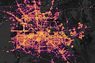
Another spacecraft, the polar-orbiting Suomi NPP satellite, captured imagery showing what the aftermath looked like from space:

An especially strong and long-lasting band of thunderstorms in Texas on May 16 and 17 produced long-lasting winds that reached 100 mph. Resulting widespread power outages in Houston continued for many days. This animation of images from the Suomi NPP satellite shows what that looked like from space. The before image is a composite based on data collected in April. The after image shows the scene on May 18. (Credit: NASA Earth Observatory)
NASA Earth Observatory
The before image in the animation is a composite showing normal night light conditions in April 2024, according to NASA. The after image shows the view from space early on May 18, after the derecho had knocked out power to large parts of Houston.
If you're wondering how these data were acquired and processed, here's NASA's detailed explanation:
"The maps are based on data from the Visible Infrared Imaging Radiometer Suite (VIIRS) sensor on the NASA-NOAA Suomi NPP satellite. VIIRS measures nighttime light emissions and reflections via its day-night band. This sensing capability makes it possible to distinguish the intensity of lights and to observe how they change."
The data from VIIRS were laid over maps from the Black Marble HD project. "The base map was built from data collected by Landsat 9," according to NASA. "Dark gray areas with hash marks are where cloud cover prevented VIIRS from collecting night lights data. The data were processed . . . to account for changes in the landscape, the atmosphere, and the Moon phase, and to filter out stray light from sources that are not electric lights."
Still another satellite also saw what happened when the lights went out:
The imagery used in this animation was acquired by the NOAA 20 and 21 polar orbiting satellites. The before image, captured March 29, shows what the city lights looked like from space on an ordinary night. The after image, acquired on May 19, shows the impact of lingering power outages around the city caused by the derecho.
What's the source of all the severe weather? I'm hoping to write a post about that in days to come.
Suffice it to say that it's linked to a violent clash between a massive, long-lasting heat dome centered over Mexico (and extending to the U.S. Gulf States), and cooler air to the north and west. In a phenomenon known as "ring of fire" weather, the jet stream has been sweeping storms along the boundary between these air masses.
Stay tuned for more...


