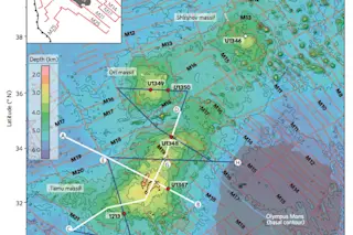
Bathmetry of the Shatsky Rise and the Tamu Massif in the Pacific Ocean. The lines represent paths of seismic profiles taken in order to interpret the structure of the oceanic crust in the area of Tamu Massif. The red dots are drilling locations on the volcanic center. Image: Figure 1 in Sager and others (2013), Nature Geosciences. Sometimes it can be difficult to separate the publicity-driven hooks for a new study in science from that actual findings of the study itself. A research paper itself is the distillation of years of works and reams upon reams of data and interpretation. Depending on the journal in which the study is published, that could mean trying to present the findings in as little as a few pages with a smattering of figures (the bigger the journal's reputation, the shorter the paper it seems to be these days). Then, that paper is taken ...
"Largest Volcano on Earth"? It Is All About Timing
Discover the Tamu Massif, the largest volcano, and its intriguing seismic profiles revealing secrets of the oceanic crust.
More on Discover
Stay Curious
SubscribeTo The Magazine
Save up to 40% off the cover price when you subscribe to Discover magazine.
Subscribe

