We have completed maintenance on DiscoverMagazine.com and action may be required on your account. Learn More

What’s Up With All This Wild, Weird Weather — And is it Linked to Climate Change?

Hundreds of tornadoes, unseasonable temperatures and more. What's the deal?

ImaGeo iconImaGeo
By Tom Yulsman
May 24, 2019 10:21 PMFeb 24, 2020 2:49 AM
Temperature Map, May 2019 - NOAA
(Credit: NOAA)

Newsletter

Sign up for our email newsletter for the latest science news
 

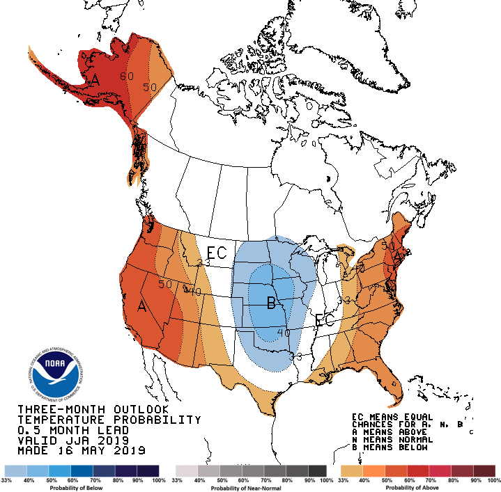
It certainly has been a wild — and deadly — few weeks for weather.

Since the first and 23rd of May, 340 tornadoes have spun up across the United States, mostly in a swath of territory stretching from Texas up through the nation’s midsection, according to preliminary reports from the National Weather Service. Compare that to an average of 276 tornadoes for the entire month.

The past week has brought particularly severe weather, with violent, hail-bearing thunderstorms spawning 206 tornadoes. These include an outbreak on May 22 in Missouri, where one twister near Joplin killed three people, and another ripped through Jefferson City, the state capitol.

Meanwhile, along Colorado’s Front Range where I live, the weather has been more characteristic of the Norwegian Arctic in April than this part of the country in late May.

Snow fell here on May 21, with three inches accumulating on my deck. And Denver managed to reach a high of only 39 degrees — the coldest high temperature for the date in 128 years of record keeping.

What accounts for the mayhem and dramatic weather contrasts? Persistent big meanders in the polar jet stream have played a major role. This has allowed wintry weather to spill south over the Western United States, while very summery air has surged north over the nation’s midsection.

Where the two very different air masses have clashed, extreme weather has erupted.

A meandering jet stream is not inherently abnormal. But human-caused climate change seems to have upped the odds that big, persistent meanders will form.

The particular chain of events that appears to have led to what we’ve been experiencing are usually seen only in winter, according to Judah Cohen, Director of Seasonal Forecasting at Atmospheric and Environmental Research. “However, this year we have seen this pattern occur in May. It is pretty rare, and as far as I can tell last occurred in 1997,” he says

Cohen believes that declining Arctic sea ice, and a resulting cascade of atmospheric effects, are implicated.

Evolution of the jet stream over North America between May 16 and 22, 2019. (Images: California Regional Weather Server/Dept of Earth & Climate Sciences, San Francisco State University. Animation: Tom Yulsman)

To fully understand that cascade, it’s helpful to start with the wavy jet stream pattern that has dominated the weather over North America for quite some time.

The animation above shows the evolution of that pattern between May 16th and 22. The shifting position of the jet stream is visualized in gray tones. Arrows indicate the direction of wind flow, and the shades of gray indicate wind speed.

Note the large southward dip in the jet stream that develops over parts of the western United States. This dip, with an associated trough of low atmospheric pressure, has allowed much cooler than average air to spill south. At the same time, a series of storms has tracked along the jet stream dip, bringing lots of late season snow to the mountains, and even to the high plains at their feet.

Just to the east, look for the corresponding northward jet stream bulge. With its associated ridge of high pressure, this bulge has brought a surge of warm air from the south.

This past week, the trough over the western United States was particularly deep. As meteorologist Bob Henson wrote recently in Wunderground’s Category 6 blog, it “wouldn’t be out of place if it occurred in February, given the frigid air in its core and the shrieking jet stream rotating around its base, packing winds of 120 to 160+ mph at flight level.”

All that energy, plus the unusually cold and warm air masses clashing over the central plains, has led to high instability in the atmosphere. Mix in extremely strong wind shear, and we’ve had the perfect recipe for supercell thunderstorms and tornadoes.

Dips and bulges in the high altitude winds that form the jet stream create a pattern known scientifically as “Rossby waves,” named after Carl Rossby who discovered them in the 1930s. Check out NASA’s visualization above to see how Rossby waves evolve over time.

The jet stream exists because of the difference in temperature between the higher and lower latitudes. And the Rossby waves that develop in the jet stream flow are part of a perfectly natural phenomenon arising from topography, uneven heating of Earth’s surface by the Sun, and Earth’s rotation.

The waves help to move heat from the tropics toward the poles, and cold air toward the tropics, thereby helping to even out temperature differences. The stronger those contrasts are, the straighter the jet stream will tend to flow, yielding Rossby waves with only small dips and bulges.

Meanders in Brazil’s Juruá River, as seen by the Landsat satellite. (Credit: USGS/NASA)

This is akin to a mountain stream flowing straight and fast downhill. But once the stream reaches the plains, it’s no longer hemmed in by the topography. And on a flatter surface, it slows down. As a result, it meanders more, creating big oxbow bends.

This is analogous to what happens to Rossby waves when the temperature difference between the higher and lower latitudes is reduced. The lobes of the waves get more pronounced, much like the river oxbow bends seen in the image above.

As humankind’s emissions of heat-trapping greenhouse gases have warmed the planet, the heating has not been uniform. Warming in the Arctic has been at least twice as pronounced as in the lower latitudes. This means the difference in temperature between the regions is not as less than it once was.

Mounting scientific evidence shows that this has caused the jet stream to behave more and more like a lazy stream flowing across the plains, with an increasing frequency of persistent big meanders — just like those we’ve been seeing this week, and earlier in the year as well.

That’s the broad picture, but the details are a bit more complex.

The large Rossby-wave meanders increasingly seen in the jet stream are tied to disruptions in the polar vortex. This is an area of low atmospheric pressure girdled by strong circulating winds that normally bottle up cold Arctic air in the north. 

These disruptions, the resulting wavy jet stream patterns, and the wintry outbreaks that ensue, typically are limited to December, January and March, AER’s Judah Cohen notes. But here we are, seeing this particular pattern in May.

What’s going on? Cohen believes the cascade of events that has led to this month’s weather mayhem is tied to the shrinking lid of floating sea ice in the Arctic.

In particular, the autumn sea ice freeze-up has been occurring more slowly than it once did. Then in spring, break-up and melting of the ice has been happening earlier.

The result: The sea surface is now exposed to the air for longer than it once was. This allows warmth and water vapor to escape from the open waters into the atmosphere. Research has shown that this, in turn, can disrupt large-scale circulation patterns in the atmosphere — including the polar vortex.

This is exactly what happened in April, with disruption of the polar vortex leading to enhanced waviness in the polar jet stream, according to Cohen. Over Scandinavia, within one of the northward-pointing lobes of the wavy jet stream, a broad area of abnormally high pressure formed.

And there it sat, stuck in place, helping to reinforce the jet stream’s waviness in what meteorologists call a “blocking pattern.”

“I do think the wild weather that we have seen, with a highly amplified trough and the anomalous cold and snow, and even the severe weather upstream, is related to sea ice loss, a weakened polar vortex, the high latitude blocking, and a more amplified jet stream pattern across the U.S.,” Cohen says.

No doubt you’re wondering what the future is likely to bring. (After so much cold and gloom in Colorado, I sure am!)

The six to ten day outlook for temperature, issued on May 24, 2019. (Credit: NOAA)

As the map above shows, for the next six to 10 days the Climate Prediction Center of the National Weather Service is forecasting a strong likelihood of warmer than normal temperatures in the southeastern United States, stretching up through the Appalachians and into the Northeast. Meanwhile, cooler than normal temperatures are expected to persist in parts of the West and in the Upper Midwest.

What about summertime?

The U.S. temperature outlook for June, July and August. (Credit: National Weather Service/NOAA)

As this map shows, the western and eastern portions of the United States have a heightened probability of warmer than normal conditions during June, July and August. But if you live in the nation’s midsection, that oblong swath of blue suggests you could be in for cooler than normal temperatures.

As I’m finishing this story on the Friday before the start of the Memorial Day weekend, the sun has finally come out here in Colorado.

And unusually for this time of year, even the foothills are glistening white with snow. It’s wonderful, and honestly, just a little weird.

1 free article left
Want More? Get unlimited access for as low as $1.99/month

Already a subscriber?

Register or Log In

1 free articleSubscribe
Discover Magazine Logo
Want more?

Keep reading for as low as $1.99!

Subscribe

Already a subscriber?

Register or Log In

More From Discover
Recommendations From Our Store
Shop Now
Stay Curious
Join
Our List

Sign up for our weekly science updates.

 
Subscribe
To The Magazine

Save up to 40% off the cover price when you subscribe to Discover magazine.

Copyright © 2024 Kalmbach Media Co.