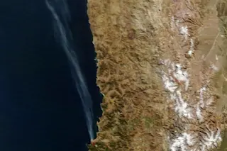
NASA’s Terra satellite acquired this image of the wildfire that swept through Valparaiso, Chile at 11:10 am local time on Sunday, April 13, 2014. (Source: NASA Earth Observatory) As a raging wildfire swept through Chile's coastal city of Valparaiso last weekend, destroying 2,000 homes and killing at least 15 people, NASA's Terra satellite captured this image of the blaze as it passed overhead. A plume of smoke is clearly visible streaming northwestward over the Pacific Ocean from areas outlined in red where the Moderate Resolution Imaging Spectroradiometer (MODIS) on Terra detected fire. The cause of the Valparaiso wildfire is still unknown, but it appears to have begun in a forest draping the steep and heavily populated hills. As of Monday, firefighters were still battling flames in some areas.
Elocuente, impresionante y triste #Valparaisopic.twitter.com/Q7tfrNl6Ie — javier (@RebolledoParra) April 13, 2014
Primed by hot temperatures and dry conditions, and whipped by high ...


