The Atlantic Ocean is Primed to Deliver "High-Octane Jet Fuel for Hurricanes"

The conditions favoring formation of Atlantic hurricanes are more extreme than ever seen before.

ImaGeo iconImaGeo
By Tom Yulsman
Jun 5, 2024 3:20 PMJun 8, 2024 1:08 PM
Sizzling Seas
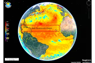
Sea surface temperatures in the main development region for Atlantic hurricanes are running extremely high, as seen in this image showing the situation as of June 3, 2024. (Credit: NOAA Coral Reef Watch)

Newsletter

Sign up for our email newsletter for the latest science news
 

The much anticipated 2024 Atlantic hurricane season is here, and with ocean heat setting records, plus a looming La Niña, it may well take an appalling toll.

Tropical cyclones are fueled by oceanic heat, and right now, the gas tank is overflowing.

As University of Miami tropical cyclone expert Brian McNoldy posted to social media the other day, "It's June 1, the first day of Atlantic #HurricaneSeason, and the ocean heat content averaged in the Main Development Region is as high as it normally would be on August 17. And incredibly, it's even higher than what 2023 was on this date."

Last year at this time, the oceanic heat was already incomprehensibly high.

Ocean heat content in the main development region for Atlantic hurricanes, as of June 4, 2024. (Credit: Brian McNoldy)

Record high oceanic heat also is an issue in the Gulf of Mexico, and in the tropical Atlantic as a whole. Mcnoldy finds this quite concerning. "First, it's a curiosity without a great explanation," he told me in an email. "But second, it's high-octane jet fuel for hurricanes. It raises the bar for their peak intensity and increases the odds of rapid intensification."

La Niña stands a 69 percent chance of developing by July–September (and nearly 50-50 odds by June-August). This raises the risks even further. That's because the climate phenomenon weakens westerly winds high in the atmosphere, reducing wind shear that would otherwise rob tropical cyclones of heat and moisture and even tear their tops away. With decreased shear stemming from La Niña, more and stronger Atlantic hurricanes should form.

Unprecedented Hurricane Forecasts

Prompted by the combination of warm oceans and the looming La Niña, a team of weather and climate researchers at Colorado State University predict that Atlantic hurricane activity this year will be about 170 percent of the 1991–2020 average season. They also forecast 23 named storms, compared to an average season of just over 14, with five storms reaching major hurricane strength. And they foresee the year's Accumulated Cyclone Energy, or ACE, in the Atlantic reaching a shockingly high number: 210 compared with an average of 123.

ACE is a measure of a named storm’s potential for wind and storm surge destruction.

Forecasters with the National Oceanic and Atmospheric Administration generally concur with these predictions, saying there's a 70 percent or greater chance of the Atlantic seeing 17 to 25 named storms, eight to 13 hurricanes, four to seven major hurricanes, and ACE between 150 percent and 245 percent of the median.

There really haven't been any other hurricane forecasts like this. We're in uncharted territory.

This image of Hurricane Wilma was taken by the crew aboard NASA's International Space Station from 222 miles above. Wilma's eye was two miles across, the smallest ever observed and characteristic of an extremely intense storm. Wilma went into the record books as the strongest observed Atlantic hurricane, with a record low central pressure. Her winds exceeded 185 miles per hour. (Credit: Wikimedia Commons)

"The combination of La Niña and the tropical Atlantic waters being this warm has never been observed before," McNoldy says. "The seasonal hurricane outlooks are all the most aggressive they've been because without any historical analogs or obvious 'brakes' on the system, all they can do is take previous years that were almost like this and extrapolate."

From Texas to Maine, more than 32.7 million residential properties are at risk of moderate or severe damage sustained from hurricane-force winds, according to a report released last week. And, of course, that doesn't include the Caribbean and Central America, where many people are particularly vulnerable to natural disasters.

The specifics of why sea surface temperatures and ocean heat have skyrocketed so much this year and last remain a bit of a mystery. But the broad climatic context is not. Last year, heat stored in the upper 2,000 meters of the world's oceans reached record highs — for the fourth year straight year, according to a paper published in January.

This should not be surprising. The oceans have been storing about 90 percent of the heat building up in the Earth's climate system as a result of the greenhouse gases we continue to pour into the atmosphere.

More From Discover
Recommendations From Our Store
Shop Now
Stay Curious
Join
Our List

Sign up for our weekly science updates.

 
Subscribe
To The Magazine

Save up to 40% off the cover price when you subscribe to Discover magazine.

Copyright © 2024 Kalmbach Media Co.