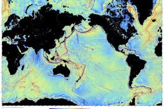
A gravity model of the Atlantic Ocean shows earthquakes over 30 years (red) and details of the seafloor's tectonic features. | David Sandwell/Scripps Institution of Oceanography, UC-San Diego
What flies above has radically changed our knowledge of what lies beneath. New maps of Earth’s seafloors derived from satellite data have identified thousands of previously unknown seamounts, faults and other tectonic features.
Researchers at Scripps Institution of Oceanography at the University of California, San Diego, created the maps by analyzing untapped data streams from NASA’s Jason satellite and the European Space Agency’s CryoSat-2 satellite. Unlike traditional shipboard sonar measurements — which bounce waves off the seafloor and have mapped out a mere 20 percent of the planet’s oceans — the satellites captured subtle variations in Earth’s gravitational pull at the water’s surface. The variations are caused by geologic features sometimes thousands of feet below the waves and even buried beneath thick ...


