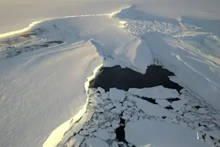
Alaska's Norton Sound on the Bering Sea is seen in this animation of images from NASA's Terra satellite. One image, acquired on Nov. 25, 2009, shows fractured sea ice filling the sound. The other, acquired on the same date this year, shows mostly open water. (The dark area to the right was not imaged by the satellite because of the polar night. Images: NASA Worldview. Animation: Tom Yulsman) With winter descending on the Arctic, sea ice should be expanding rapidly in the Bering and Chukchi seas off Alaska and eastern Siberia. But instead of sea ice, satellite sensors see thousands of square miles of open water stretching between the Alaska and Russia. "It’s the lowest ice extent on record for this time of year for the combined basins," according to Rebecca Lindsey of the National Oceanic and Atmospheric Administration. I created the animation above using images from NASA's Terra satellite ...
Satellite imagery shows just how bad the loss of Arctic sea ice has been off Alaska and eastern Siberia
Arctic sea ice extent is at a historic low as open water dominates the Bering Sea instead of expected ice. Discover why this is happening.
More on Discover
Stay Curious
SubscribeTo The Magazine
Save up to 40% off the cover price when you subscribe to Discover magazine.
Subscribe


