We have completed maintenance on DiscoverMagazine.com and action may be required on your account. Learn More

Satellite imagery reveals the stunning scope of historic flooding inundating the Midwest

ImaGeo iconImaGeo
By Tom Yulsman
Mar 20, 2019 2:10 AMNov 19, 2019 9:21 PM
Omaha-Closeup.gif

Newsletter

Sign up for our email newsletter for the latest science news
 

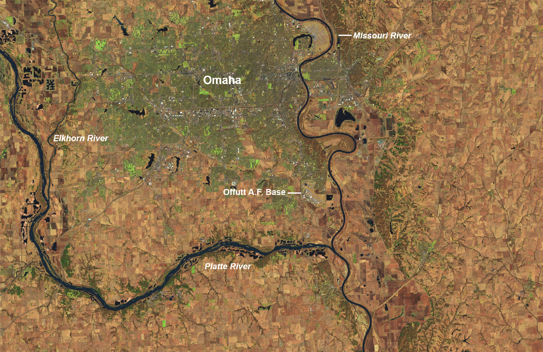
Before and after satellite images reveal the extent of flooding on the Platte, Missouri and Elkhorn rivers near Omaha, Nebraska. (Images: NASA Earth Observatory. Animation: Tom Yulsman) Flooding characterized by the National Weather Service as "major to historic and catastrophic" is continuing across parts of the central plains and Upper Midwest. The flooding has come in the wake of last week's "bomb cyclone," which dumped heavy rain atop snowpack with high water content. The resulting runoff has triggered record-setting flooding throughout the Missouri and Mississippi river basins. As I'm writing this on the afternoon of Tuesday, March 19, more than 8 million people are under flood warnings — and rain showers forecast into this evening could make things even worse. The scope of the flooding in the Omaha, Nebraska area is dramatically illustrated in the before-and-after animation above. I created it using false-color imagery from the Operational Land Imager on the Landsat 8 satellite. The 'before' image was acquired on March 20, 2018. The 'after' image is from March 16, 2019. As NASA puts it:

Several communities west of Omaha (between the Elkhorn and Platte Rivers) either flooded or temporarily became islands as floodwaters encroached from both sides. One third of Offutt Air Force Base was inundated and 30 buildings were damaged, according to news reports. Rising flood waters forced people in dozens of communities to evacuate.

To make the close-up images in the before-and-after animation showing the Omaha area, I actually cropped in on much broader Landsat views of the region. Here's what they look like:

Before and after views of the Missouri and Mississippi river basins, as seen by the Landsat 8 satellite on March 20, 2018 and March 16 of this year. (Images: NASA Earth Observatory. Animation: Tom Yulsman) For a sense of scale, it is about 150 miles as the crow flies from bottom right to top left of the images in the animation above. To further get your bearings, Omaha is in the middle along the bottom. You can make out the city better in the 'before' image. (If the animation is not working, try refreshing the page.)

Flooding along the Des Moines River is revealed in this before-and-after sequence consisting of images from the Landsat-8 satellite. (Images: NASA Earth Observatory. Animation: Tom Yulsman) Although Nebraska caught the worst of the flooding, Iowa has been hard hit too — as the animation of Landsat-8 images above shows. One image in the sequence shows the scene in March of 2018. The other was acquired on March 18, 2019. The city of Des Moines is in the middle to the left, downstream of a large reservoir in the upper left corner. Dark blue colors reveal water. Lighter blue tones are indicative of ice, which has become backed up behind dams. The broadest swath of blue shows flooding along the Des Moines River. Also hard hit is the Raccoon River, just to the west of Des Moines. Here's a broader view of Iowa:

This animation of satellite images shows before and after views of Iowa. (Images: NASA Worldview. Animation: Tom Yulsman) The 'before" image in this animation was acquired by NASA's Terra satellite on March 14, 2018. The 'after' image is from the Aqua satellite on March 15, 2019. To my eye, significant flooding along the Iowa River, which runs through Iowa City toward the right side of the image, is particularly noticeable.

1 free article left
Want More? Get unlimited access for as low as $1.99/month

Already a subscriber?

Register or Log In

1 free articleSubscribe
Discover Magazine Logo
Want more?

Keep reading for as low as $1.99!

Subscribe

Already a subscriber?

Register or Log In

More From Discover
Recommendations From Our Store
Shop Now
Stay Curious
Join
Our List

Sign up for our weekly science updates.

 
Subscribe
To The Magazine

Save up to 40% off the cover price when you subscribe to Discover magazine.

Copyright © 2024 Kalmbach Media Co.