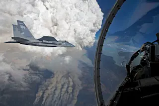
A developing pyrocumulus cloud above the Oregon Gulch fire, part of the Beaver Complex fire. Photographed from an Oregon Air National Guard F-15C fighter jet by James Haseltine on July 31, 2014, at 8:20 PM Pacific Daylight Time. (Photo: James Haseltine via NASA Earth Observatory) On Sunday, I posted satellite images of massive fire clouds billowing from wildfires raging along the California-Oregon border. On Tuesday, NASA's Earth Observatory weighed in with more details, as well as spectacular photographs taken on the evening of July 31 by James Haseltine from an Oregon Air National Guard F-15C fighter jet — including the one above. And this one too:
A gargantuan pyrocumulus cloud, as seen from an F-15C fighter jet on July 31, 2014. (Photo: James Haseltine, via NASA Earth Observatory) Rising air currents over wildfires can carry water vapor high into the atmosphere, causing it to cool and condense. If enough water ...


