Stay Curious

SIGN UP FOR OUR WEEKLY NEWSLETTER AND UNLOCK ONE MORE ARTICLE FOR FREE.

Sign Up

VIEW OUR Privacy Policy


Discover Magazine Logo

WANT MORE? KEEP READING FOR AS LOW AS $1.99!

Subscribe

ALREADY A SUBSCRIBER?

FIND MY SUBSCRIPTION
Advertisement

California's Rampaging Oak Fire as Seen From Space

Dramatic satellite imagery reveals the scope of the blaze — now as large as Manhattan Island and burning out of control.

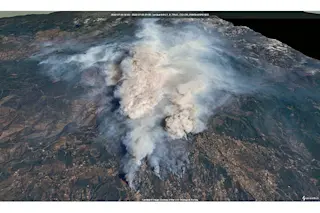
California's Oak Fire, as seen by the Landsat satellite on Sunday, on July 24, 2022. The image is rendered in a simulated 3D view.Credit: Modified Landsat data processed by Tom Yulsman using Sentinel Hub EO Browser

Newsletter

Sign up for our email newsletter for the latest science news

Sign Up

So far, California's Oak Fire blazing near Yosemite National Park has burned through through 14,281 acres — an area equivalent to the size of Manhattan Island. That makes it California's biggest wildfire this season.

As of Sunday, July 24, it has forced at least 3,000 people to evacuate, has destroyed 10 structures, some of them homes, and is completely uncontained, according to the California Department of Forestry and Fire Protection. The cause of the blaze, which began in the afternoon of July 22 about two miles northeast of Mariposa, is under investigation.

“The fire is moving quickly," Daniel Patterson, a spokesman for the Sierra National Forest, said Saturday, quoted by Wildfire Today. "This fire was throwing embers out in front of itself for up to two miles yesterday. These are exceptional fire conditions."

The blaze exploded in intensity and size on Saturday. Here's what that looked like from space, as ...

Stay Curious

JoinOur List

Sign up for our weekly science updates

View our Privacy Policy

SubscribeTo The Magazine

Save up to 40% off the cover price when you subscribe to Discover magazine.

Subscribe
Advertisement

0 Free Articles