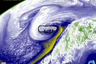
A powerful cyclone swirls in the Northern Pacific Ocean off Alaska in this animation of satellite water vapor imagery. (Source: CIMSS) I spotted this beautiful animation of a powerful Pacific Ocean cyclone in the Twitter feed of Scott Bachmeier from the Cooperative Institute for Meteorological Satellite Studies. It's so awesome that I just had to share it. The storm, as seen in the animation of GOES-15 weather satellite images above, has been spinning up in the Pacific Ocean and is headed into the Gulf of Alaska. As I'm writing this, the National the National Weather Service has issued a hurricane-force wind warning, which means the storm has either achieved hurricane strength (sustained winds of greater than 74 miles per hour), or it is predicted to do so. (For the latest Pacific high seas forecast, go here.) It's important to note that this is not a hurricane, since it is not ...
A likely hurricane-force cyclone spinning up in the Pacific is captured in this stunning satellite image animation
Discover a powerful Pacific Ocean cyclone swirling off Alaska, with hurricane-force winds and an upcoming bomb cyclone forecast.
More on Discover
Stay Curious
SubscribeTo The Magazine
Save up to 40% off the cover price when you subscribe to Discover magazine.
Subscribe

