Dora is the Western Hemisphere's 1st hurricane-strength storm of 2017
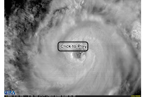
The GOES-16 weather satellite captured this view of Hurricane Dora churning in the northeastern Pacific Ocean on Monday, June 26, 2017. (Source: RAMMB/CIRA GOES-16 Loop of the Day) Click on the screenshot above and say hello to Dora, the first storm of 2017 in the Western Hemisphere to reach hurricane strength. The imagery that went into the animation comes from NOAA's new GOES-16 weather satellite. This is the first hurricane that the satellite has tracked since it was launched in November of 2016. As I'm writing this late on the afternoon of Monday, June 26th, Dora is a Category 1 hurricane with maximum sustained winds of 90 miles per hour, with stronger gusts. The tropical cyclone is moving away from the coast of southwestern Mexico and is forecast to pass well south of the Baja California peninsula on Tuesday. The Mexican coast will probably get some heavy rain, but Dora poses no significant threat on land. (For the latest information on Dora from NOAA, go here.) The Advanced Baseline Imager, or ABI, is the primary instrument on GOES-16, and it is far more capable than the current imagers found on the operational GOES-East and GOES-West satellites. It can create an image of Earth’s full disk in just 5 to 15 minutes, compared to every three hours for the current satellites. But its capabilities don't end there. Among other things, the ABI can provide high definition imagery of severe weather as often as every 30 seconds. That's getting darn close to real time! GOES-16 currently is on its shakedown cruise. Scientists are still testing everything out and evaluating the data being returned by the satellite. So it is not yet officially operational. That may come as soon as November.


