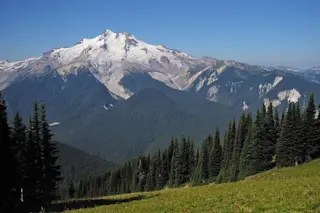
Glacier Peak in Washington. Wikimedia Commons. One of the most potentially dangerous volcanoes in the Cascades is Glacier Peak in Washington. It produced the one of the largest eruptions in the past 20,000 years in this volcanic range that spans from British Columbia to California. Multiple eruptions around 13,500 years ago spread ash all the way into Montana. Over the last 2,000 years, there have been multiple explosive eruptions that have impacted what became Washington state and beyond. Put on top of that the many glaciers on the slopes of Glacier Peak that could help form volcanic mudflows (lahars) during a new eruption, and you can see that Glacier Peak is a real threat. Yet, even with this hazard posed by the volcano, there is very little in the way of monitoring equipment on the volcano. Currently, there is a lone seismometer on Glacier Peak to measure earthquakes, one of ...
Wilderness vs. Monitoring: The Controversy of a New Seismic Network at Glacier Peak
Glacier Peak volcano monitoring is essential due to its hazardous eruptions. Learn about the need for more seismic stations in the area.
More on Discover
Stay Curious
SubscribeTo The Magazine
Save up to 40% off the cover price when you subscribe to Discover magazine.
Subscribe

