We have completed maintenance on DiscoverMagazine.com and action may be required on your account. Learn More

The Lost World of the Maya is Finally Emerging From the Jungle

From massive fortresses to sprawling suburbs, a bold new vision of the vanished Maya civilization takes shape.

By Nathaniel Scharping
Feb 7, 2019 12:00 AMDec 13, 2019 11:40 PM
Maya Guatemala then and now - Shutterstock, Estrada-Belli
In Guatemala’s Tikal, only the peaks of monuments rise above the forest. But Lidar scans reveal a complex landscape beneath the foliage. (Credits: Top, Matthias Kestel/Shutterstock; bottom, Francisco Estrada-Belli/PACUNAM)

Newsletter

Sign up for our email newsletter for the latest science news
 

Thomas Garrison pauses in the middle of the jungle.

“That’s the causeway right there,” he says, pointing into a random patch of greenery in the Guatemalan lowlands.

I squint, trying to make out features in the tangled rainforest undergrowth. There’s a small lump, rising no more than a foot or two from the forest floor.

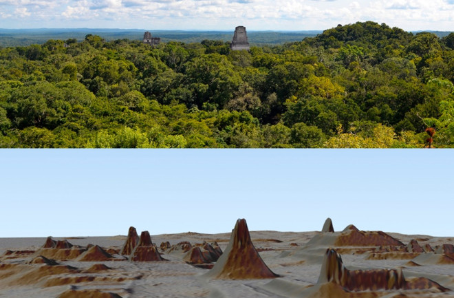
The Ithaca College archaeologist has spotted the buried remnants of a Maya road, a ribbon of limestone that once cut through the wrinkled landscape. We’re a full day’s walk from civilization, standing in the remains of a once-populous kingdom. The road before us is just one piece of a vast network leading to terraced fields, reservoirs, defensive fortifications and more, all sprawling invisibly throughout the forest.

In the 1,000-plus years since the Maya society collapsed, the jungle has returned with a vengeance. A tide of flora has swallowed up roads and temples, turning stone structures into lumps and mounds indistinguishable from the natural topography.

Garrison, an expert at picking out buried structures, had walked right by this road for years, never knowing it was there. But now, a revolutionary technology called lidar is giving archaeologists a God’s-eye view of the rainforest — and what’s buried beneath.

Lidar, which stands for light detection and ranging, bathes the jungle canopy in a stream of laser beams delivered from planes flying above. As the light bounces back, it creates a precise map of surface contours beneath the forest canopy.

Back in camp, Garrison pulls up the data on his laptop. Maya ruins leap from the featureless jungle, giving new meaning to the landscape that surrounds us. The researchers’ base shows up as a small huddle of buildings; surrounding it, hundreds of Maya structures stipple the ground in every direction. Some Garrison knew about — the majority, however, are brand new. To him, at least.

Rough roads and heavy rains make travel to and from Thomas Garrison's site difficult: teams must leave before the rainy season or risk getting stuck, like this truck. (Credit: Nathaniel Scharping/Discover)

Back in 2016, Garrison and a group of archaeologists organized a sweeping lidar survey of the heart of Maya civilization, once centered here in the Guatemalan lowlands. Their scans covered 800 square miles across the Petén region, which covers much of Guatemala’s northern half. It’s just a fraction of the former Maya territory, yet lidar revealed some 60,000 previously unknown structures.

Now, researchers can comprehend the full scale of this ancient civilization, from vastly expanded trade and agriculture to surprising military sophistication. After decades of digging, new and exciting dimensions of Maya society are finally coming to light.

Peephole to Panorama

Over a thousand years ago, the Maya dominated this environment. They emerged around 1000 B.C. and, over the next millennia, rose to become the pre-eminent Mesoamerican civilization.

Millions of people lived in the forest, members of a loose alliance of interconnected city-states. The Maya developed a system of writing, as well as a calendar system and sophisticated astronomical charts. In a world without metal, they built towering temples in cities like Tikal and Chichén Itzá, as well as roads, reservoirs, irrigation networks and terraced fields. Their civilization spanned thousands of square miles of jungle across Central America.

Lidar scans of individual locations in northern Guatemala have revealed many hidden structures. Future scans will likely include an even broader range of site. (Credit: Alison Mackey/Discover)

In the past, archaeologists have relied on small, scattered dig sites to describe the scope of this vast civilization. That’s given us a limited view of the Maya.

We’ve unlocked the secrets of the Maya language, peeled back the jungle at sites like Tikal, and stuffed museums full of ancient artifacts. These efforts have revealed many details of Maya life, but not the full scope of it. Several mysteries remain. How complex was their society? How did city-states grow and fall and grow again? And how did a civilization untouched by the Iron Age rise from the forbidding jungle — only to fall apart?

“If we just do excavations of small areas, you get just this little peephole view of the Maya people,” says Timothy Hare, a professor of anthropology at Morehead State University who’s involved in a similar mapping project. Lidar is putting the ancient society into a much broader context. Mounds and hills now stand out as temples and fortresses tied to suburbs and farmlands.

“It gives you a sense of connections across a big area, as opposed to just little points of information from this mound or that pyramid or that temple,” says Stephen Houston, a Maya archaeologist at Brown University who works with Garrison’s team. “Suddenly everything becomes connected, everything is seen as being part of a single functional space.”


Beneath The Canopy

Lidar = Light Detection And Ranging

To create Lidar images, airborne instruments fire at the ground millions of laser pulses, which reflect back up. By timing how long it takes the pulses to return, and combining that data with precise GPS data, researchers can create a map of the surface beneath the vegetation. These can be accurate down to about a square meter, enough to pick out hidden temples, roads, watchtowers and much more.

Garrison uses various filters to draw further contrasts out of the resulting maps and highlight where ancient structures might be. It can take months to turn lidar data into useful information — such as these terrain maps of Dos Torres, in the hills between Tikal and Uaxactun. (Credit: Luke Auld-Thomas and Marcello A. Canuto/PACUNAM)

The network of crowded canals (blue lines) revealed near Tikal are evidence of centuries of work — infilling, erosion and re-excavation — by the ancient Maya. They are located in a low, swampy area called a bajo, common in much of the Guatemalan lowlands. The Maya nevertheless figured out how to engineer the landscape to make it suitable for crops. Buildings (black dots) huddle nearby. (Credit: PACUNAM)

Violent Past

The iconic Temple IV at Tikal — once featured in Star Wars — draws tourists from around the world. Tikal’s famed summit is barely visible across the jungle canopy from the Temple of the Night Sun, a hidden pyramid in the nearby ruined city of El Zotz. Unlike Tikal’s tourist mecca, the Temple of the Night Sun is still slowly fading into the jungle. As I travel with Garrison, it’s our destination — if we can make it through the dense foliage.

Fifteen hundred years ago, the jungle would have been much more hospitable. Tikal, where temples have been methodically cleared of overgrowth, offers a hint of what Guatemala may have looked like back then. Broad pathways linked temple complexes. Stone buildings bounded spacious courtyards. Outside of city centers, clusters of fields and reservoirs broke up the jungle. Villages were nestled into nearby clearings.

Today, some 14 miles of thick jungle separate El Zotz from Tikal’s metropolis. But in the time of the Maya, the two were almost too close for comfort. Garrison’s excavations here reveal an alternating history of aggression and allegiance with Tikal, as the dynasty at El Zotz waxed and waned in concert with their larger neighbor.

A crumbling wall near the top of the Temple of the Wooden Lintel, at El Zotz, is one of the few structures Garrison has been allowed to clear of vegetation. (Credit: Nathaniel Scharping/Discover)

On one side of the Temple of the Night Sun’s pyramid, archaeologists have carved a tunnel. It twists and turns through layers representing hundreds of years of Maya construction. Inside, fearsome stucco masks adorn what was once a temple atop the structure. They represent a central figure in the Maya pantheon, the Sun God, who transformed into a jaguar at nightfall. Deeper inside lies a find unearthed during the 2010 season: a royal tomb containing the remains of the El Zotz dynasty’s founder, alongside exquisite ceramics and the bones of sacrificial children.

At some point, however, the Maya abandoned this temple complex, uprooted the heart of the kingdom and moved to a new location, about a half-mile downhill. Garrison thinks the sudden move was likely related to a time of great upheaval in this part of the Maya world.

At some point, however, the Maya abandoned this temple complex, uprooted the heart of the kingdom and moved to a new location, about a half-mile downhill. Garrison thinks the sudden move was likely related to a time of great upheaval in this part of the Maya world.

In A.D. 378, Tikal fell to a distant power — the city today known as Teotihuacan, far to the northwest in Mexico. Tikal’s king was killed and replaced by an outsider, and the kingdom became something like a vassal state to the foreign state.

Garrison and Houston disagree as to the exact effects of this violent usurping. Houston argues it was a time of devastation and tragedy for the Maya; their dynasty was toppled and their culture was subsumed by another. To live in Tikal at this time would have been to exist under the heel of a foreign power, he says.

Garrison sees a different narrative. Though the change of rulers was certainly brutal, he argues that the result was ultimately beneficial. As evidence he points to the fact that the city rapidly expanded its territory in the aftermath, and likely allied itself with El Zotz.

The result was a new era of prosperity for El Zotz still evident today. Walking through the grassy city center, we pass multiple temples, mortuary complexes and a ball court. Public markets were likely held nearby, and the city is surrounded by outlying groups of Maya homes where thatched huts once stood; what were likely cacao fields lie farther up in the hills.

This area has been thoroughly examined and plotted, the result of seven years of meticulous work. Had lidar been around then, that work would likely have been much quicker. The technology has transformed the day-to-day work of archaeology in the jungle. Uncovering ruins once required informed guesswork; now the team can pinpoint spots of interest.

“Some days you’d go and you’d be trudging all day and you’d get to this hilltop where you’re excited to find something, and you get there and there’s just nothing,” Garrison says. “That never happens with Lidar. When you go out to do your recon or your ground truthing, you know exactly where you’re gonna end up that day.”

Garrison inspects a large stone mask — the Jaguar God of the Underworld — in the Temple of the Night Sun, part of the El Diablo group of structures near the Temple of the Wooden Lintel. (Credit: Robert Perkins/USC)

Hidden Connections

Garrison has a surplus WWII gas mask bag slung over his shoulder — the same satchel Indiana Jones carried. He’s got the jacket, too, and once had a whip to complete the look, though it has since been lost. “An ex-girlfriend took it to Burning Man,” he says.

Garrison exudes an understated confidence after nearly 20 years of fieldwork, but he’d been getting restless at El Zotz, which had been shaping up to be fairly unspectacular by Maya terms. Other than the royal tomb, they’d uncovered few major finds. That is, until 2016. And lidar.

“Now it’s like a whole new place,” he says.

The new data is enough to upend some previous theories. A 2,700-year-old site called El Palmar sits not far from El Zotz, and was once thought of as a small town. Now, it appears to have been a major metropolitan area. Roads radiate out from its center, connecting the city’s heart to outlying villages, nearly all of which were hidden before the lidar scans.

“We thought [it] was this Podunk little . . . site on the edge of this lagoon, and now it’s enormous. It’s 40 times larger than we thought it was,” Garrison says. “This is now this huge city that would have been a rival to Tikal.”

The scans also hint that the Maya territory wasn’t homogenous. In the eastern Petén Basin, there’s a strange concentration of agricultural fields. It may have been a kind of breadbasket for the rest of the region, Garrison thinks.

And near El Zotz, the cacao fields could indicate a form of specialization, where farmers traded beans for other staples. Large community markets were likely common in Maya society.

In addition to turning towns into cities, the lidar data occasionally reveals something even more exciting — not just new structures, but new dimensions of Maya society. On a hillside near the old temple complex at El Zotz, lidar revealed a dotted line that ended up being rudimentary fortifications, built to slow incoming attackers. Just this year, Garrison’s team uncovered a mound of sling stones at the site, potential ammo cached over 1,000 years ago by some prudent defender. The hillside reveals that the threat of warfare was more pervasive in Maya society, even far before its collapse, than archaeologists believed.

And bolstering that theory is an even more surprising discovery. Nearby, in the hills above El Zotz, Garrison has found the ruins of something unprecedented in Maya archaeology.

Garrison (left) and his excavation team work on reopening a tunnel into the Temple of the Wooden Lintel, one of the main pyramids in the ruins of El Zotz. His team‘s finds have helped expand our understanding of the city-state, and its tumultuous relations with its neighbors. The advent of Lidar mapping has only accelerated the pace of discovery. (Credit: Robert Perkins/USC)

Maya Warfare

Named La Cuernavilla by Garrison, the site is mostly unstudied. But lidar scans reveal a clear function: The place was a fortress.

Set atop an imposing ridgeline, the fort’s impressive scale indicates that whoever occupied it either felt a real threat of attack or wanted to make a show of overwhelming force.

La Cuernavilla includes a temple, palace and the remains of housing platforms, as well as a moat and a massive wall some 25 feet high. One side is protected by a sheer cliff, and the other is strategically fortified with defensive terraces. A watchtower sits nearby — another first for Maya archaeologists — part of a newly discovered defensive network that spreads throughout the entire Maya lowlands.

It’s the first time archaeologists have found Maya structures built expressly for warfare, and it implies an unexpected level of military engineering. Garrison estimates he came within about 100 feet of it on previous digs.

“It’s amazing. It’s so new. This is the kind of thing that no one ever suspected to show up,” says Michael Coe, a Yale University archaeologist and Maya scholar who’s not involved with the team. “It’s a major discovery.”

Excavations so far suggest the site was occupied for centuries. Garrison’s team also unearthed a building that resembles those at Teotihuacan. It’s a strong hint that, after the Mexican city-state’s invasion of Tikal, they began expanding their influence on the surrounding countryside in earnest. The fortress was likely overtaken by Tikal’s new rulers, and could have served as a military stronghold for the occupying forces.

When combined with the network of watchtowers, the fortifications look even more strategic. The defensive network seems to spread for miles around El Zotz. And if Garrison is right about this fortress’s association with Tikal, it means that the city-state was building military outposts throughout the region to consolidate control on behalf of far-away Teotihuacan.

This includes the fortifications that Garrison discovered at El Zotz, which may be part of a larger network. The series of paved limestone platforms interspersed with rocky, tortuous terrain would let defending troops rain sling stones and projectiles down on incoming warriors.

“To me, it’s obvious that these are not just Balkanized little hilltop fortifications, but this represents some kind of system,” says Houston, a former site director at El Zotz. “Someone invested a lot of money in these, a lot of sweat, a lot of effort.”

Though some researchers have long argued that Maya civilization was bigger than assumed, this is the first evidence of strategic defensive fortifications, or what Houston calls “an aggressive landscape of surveillance.”

The organized military activity hints at a new conception of Maya society. The level of resources and planning needed to build La Cuernavilla implies a society with powerful militaristic organization, something that researchers have never before suspected.

Digging In

This evidence of sophisticated military might could be the final piece of evidence that solidifies a theory long gestating in Maya archaeology: that they were much more hierarchically organized than previously thought. The presence of sophisticated agriculture and widespread engineering projects had hinted at a high level of societal control. But University of Nevada, Las Vegas, archaeologist Arlen Chase argues a focus on interpreting Maya hieroglyphics kept getting in the way.

“They’re far more centralized than people have given them credit for,” Chase says. “Because the hieroglyphs didn’t talk about economics, it was assumed that there was no centralized control of economics, no centralized control of anything.”

Now, thanks to lidar, new sites like La Cuernavilla are indicating the opposite. “This is the activity of a well-oiled state machine,” Garrison says.

His team is now excavating the fortress grounds themselves, collecting pottery fragments to find out when the site was occupied. The scans are great for finding things, but can’t establish a timeline. For this task, old-fashioned digging is really the only option, and Garrison sees years of work ahead. He and Houston recently secured two grants, from the National Science Foundation and the National Endowment for the Humanities, to fund more excavations at the site.

Structures at a previously unknown Maya site, which Garrison has named La Cuernavilla, show that it was heavily fortified. Lidar revealed a palace group below a steep ridge, with a causeway leading to more structures atop the hills. Ditches, ramparts, moats and walls indicate that its inhabitants were prepared for war. La Cuernavilla spans about 1.5 miles across. (Credit: Thomas Garrison/PACUNAM)

The Vanishing

This new picture could also help unravel why Maya society quickly — and for the most part mysteriously — vanished around A.D. 900. Though there’s evidence of increased warfare toward the end, what likely precipitated the fall was a drought. A study by scientists from Cambridge University and the University of Florida, Gainesville, published in Science last August, shows that rainfall dropped by roughly half at the time of the civilization’s collapse.

For a society dependent on irrigation to water their crops, it could well have been a death knell.

For centuries, ingenious Maya engineers had altered the landscape in their favor: creating canals to water fields, reservoirs to hold rain through the dry season, turning wetlands to fertile soil, and carving terraces into hillsides. But even with these human enhancements, the Maya remained at the mercy of nature’s beneficence. Eventually, it ran out.

As the drought dragged on, warfare, already somewhat common between antagonistic city-states, seems to have become even more prevalent. The discovery of La Cuernavilla is poised to help researchers probe this angle further by illuminating the intricacies of Maya militarism. Though the site seems to have been most active centuries before the collapse, better understanding how the Maya engaged in conflict, and to what extent it was integrated into their society, will help researchers understand the sequence of events that led to the demise of their society.

We do know, though, that little food and too much fighting likely led people to abandon cities; many probably perished. The Maya population dropped around 90 percent during this time. Though a few cities would struggle on, the Maya never returned to their former glory. Those who survived fell back into the jungle or squatted in cities.

Echoes of Civilization

Leaving the research camp, we drive into the gloom of an approaching thunderstorm. Dark mounds loom around us as the battered truck pushes past concrete huts. Occasional lightning bolts paint the distant hills in silhouette, and I wonder what lies beneath them. Garrison’s data make clear that the Maya didn’t just build cities and towns here in the Petén — they inhabited nearly every square mile of the area.

Each hill, every bump in the ground, may conceal the remains of civilization, and with the echoes of laser beams raining down through the jungle, we’ll soon find them.

Garrison is confident that he’s beginning to get a handle on this landscape he’s trekked for years, but never truly seen. It’s right here, on his laptop screen. Now all he needs to do is go out and dig. 


Nathaniel Scharping is an assistant editor at Discover. This story originally appeared in print as "A Lost World Emerges."

1 free article left
Want More? Get unlimited access for as low as $1.99/month

Already a subscriber?

Register or Log In

1 free articleSubscribe
Discover Magazine Logo
Want more?

Keep reading for as low as $1.99!

Subscribe

Already a subscriber?

Register or Log In

More From Discover
Recommendations From Our Store
Shop Now
Stay Curious
Join
Our List

Sign up for our weekly science updates.

 
Subscribe
To The Magazine

Save up to 40% off the cover price when you subscribe to Discover magazine.

Copyright © 2024 Kalmbach Media Co.