Maya Water System Discoveries Show the Ancient Civilization in a New Light

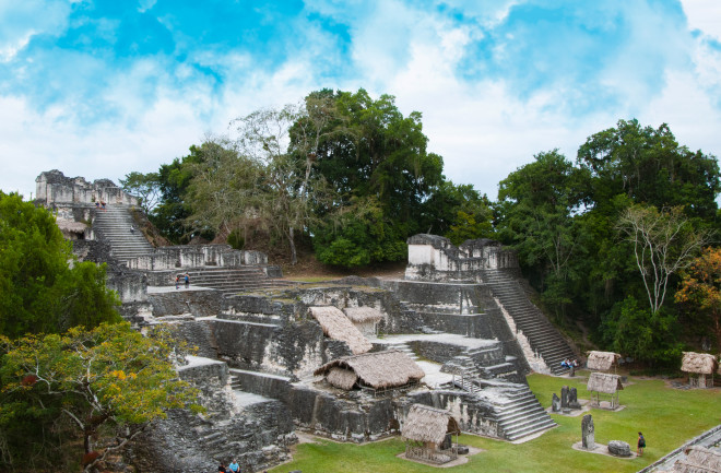
Elaborate water and irrigation systems, overlooked for decades by archaeologists, are getting their due.

By Leslie Nemo
Dec 1, 2020 2:40 PMDec 1, 2020 3:40 PM
Maya ruins in Tikal, Guatemala
(Credit: Godofwarr/Shutterstock)

Newsletter

Sign up for our email newsletter for the latest science news
 

During the two centuries Western archaeologists have excavated and investigated ancient Maya sites, comparatively little time has been spent understanding the structures that kept cities functioning for centuries. "Unfortunately, there's this almost 200 year legacy of people focused on burial chambers and temples and hieroglyphics," says Kenneth Tankersley, an archaeological geologist at the University of Cincinnati. "No one had been asking the question, 'well, how did these people survive in this biologically stressful environment?'"

But over time, a decidedly mundane portion of ancient Maya life has entered the spotlight: water management. Research and excavations have gradually shown that ancient civilizations in what is now Mexico, Guatemala and Belize modified landscapes to ensure regional water cycles worked for farmers and fed thriving cities. In a stretch of land hit with alternating hurricanes and droughts, Maya ancestors scooped out reservoirs and dug drainage systems capable of holding and transporting water. And the more researchers learn, the more the forged landscapes shine as marvels of ancient Maya culture.

A Flawed Western Perspective

When early archaeologists first examined ancient Maya remains, they fixated on wealth and power, such as temples, graves and their extravagant contents. This was in part because the investigators themselves were rich. The work was a hobby conducted and funded by wealthy Europeans. “Early gentlemen scholars were interested in the elite because they were elite,” says Adrian Chase, an archaeologist at Arizona State University. Europeans also first arrived in Central America on a quest for wealth. That attitude — and search — bled into the first archaeological explorations. Additionally, Western ideas about agriculture influenced how researchers thought residents could put land to use. Dense jungle seemed somewhat impossible to transform into agricultural fields for those who were used to seeing flat plains.

As research continued over the years, archaeologists began to reconsider their assumptions. In the 1970s, attempts to map Tikal, a major Maya city in Guatemala, showed that it was so densely populated that the inhabitants must have relied on a kind of agriculture that farmed the same plots of land repeatedly. It seemed to be the only way to feed a relatively packed metropolis.

Further excavations showed that terraces, or giant shallow steps, carved into hillsides contain layers of modified soil. Each step carries so few rocks that residents must have intentionally removed material from the Earth, and the design of each step allowed water to flow from one to the next.

In the early 2000s, LiDAR technology made its way into ancient Maya research projects. The imaging system emits bursts of radar beams from above and builds a topographic map of the land below by tracking where each of those beams makes contact. LiDAR maps can show a landscape as if it were stripped of any plants — a particularly handy feature when working with former Maya settlements now covered in dense jungle.

With this technology, archaeologists started to see the landscape features, reservoirs and terraces with exceptional detail. They also saw buried infrastructure they didn’t necessarily know to search for. “Looking through the vegetation and actually looking at the landscape,” Tankersley says, “wow — it's overwhelming.”

The growing knowledge about ancient Maya water infrastructure has helped researchers see how dense urban life was possible, even in a region dominated by forest and lacking rivers or other obvious water sources. Residents dammed sinkholes and carved reservoirs to hold water dumped onto the territory during rainy seasons and tapped into their reserves when drought set in. Agricultural fields cut into hillsides, caught water and slowly drained it down the slope into the steps just below, ensuring each thin, rectangular plain received moisture while retaining nutrient-rich soil. To this day, trees that have grown over Maya agriculture terraces are taller and have denser vegetation than those growing on similarly-sloped hillsides in the area.

The First Water Filter System?

Researchers are still teasing out even more details about the complexity of Maya infrastructure from the water systems. A recent soil analysis, conducted by Tankersley and his team on a reservoir in Tikal, found zeolite, a mineral still used today to filter out water contaminants. The crystals aren’t found naturally in the regional soil. But roughly 30 kilometers away, deposits of tuff — volcanic ash turned to rock, which often holds zeolite — sit above an aquifer known locally for its sweet and clear water. Tankersley and his team think that when Tikal residents used the reservoir 2,000 years ago, they must have harvested the tuff and its embedded zeolite and brought the material to their own reservoir in order to improve the water quality. When flooding from the rainy season washed the filtration system away, locals would reinstall it, packing the material into the earth just upstream of the basin. If this is the intentional water filtration system Tankersley and his colleagues think it is, it would be the oldest of its kind yet found. 

Chase, who focuses on the neighboring city of Caracol, is curious to see what else Tankersley and his team find with these soil investigations. Theoretically, the entire Tikal reservoir could have supported much of the city population with drinking water through droughts. But some of Tankersley's earlier research in the former watering hole showed evidence of a harmful pathogen called cyanobacteria as well as other toxins, suggesting that maybe polluted drinking waters contributed to people eventually abandoning Tikal. Clear evidence of contaminated water quality might count as a strike against the idea that the Tikal reservoir was meant to quench the thirst of residents, Chase says. But the latest evidence of a possible filtration system at this water source supports the possibility.

Since the urban center of Caracol is relatively close to Tikal, it's plausible that Caracol residents could have brought the filtration mineral into their own reservoirs, too — a possibility Chase plans to investigate with similar soil sampling technology. 

1 free article left
Want More? Get unlimited access for as low as $1.99/month

Already a subscriber?

Register or Log In

1 free articleSubscribe
Discover Magazine Logo
Want more?

Keep reading for as low as $1.99!

Subscribe

Already a subscriber?

Register or Log In

More From Discover
Recommendations From Our Store
Shop Now
Stay Curious
Join
Our List

Sign up for our weekly science updates.

 
Subscribe
To The Magazine

Save up to 40% off the cover price when you subscribe to Discover magazine.

Copyright © 2024 Kalmbach Media Co.