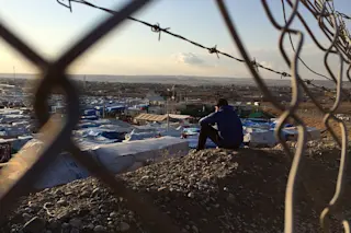
A refugee camp in the Kurdistan region of Iraq (Photo Credit: Flickr EU/ECHO/Caroline Gluck/CC BY-ND 2.0) By analyzing images taken during times of humanitarian crises, citizen scientists can help refine a tool for data analysis improve relief efforts.A guest post by Megan Passey and Jeremy Othenio. Edited by Arvind Suresh In August 2014, following the fall of Mosul in Iraq, the UN declared the situation a level 3 crisis, the most severe type of humanitarian emergency. Iraq was already home to an estimated 1 million internally displaced persons prior to the current crisis, as well as over 200,000 refugees from Syria. During such disasters, there is a massive surge of time-sensitive information that needs to be sifted through. Having a system that quickly examines and produces pertinent data sets from this information could greatly aid humanitarian response efforts. As part of its humanitarian relief and coordination efforts, the United Nation’s ...
Citizen Scientists Like You Could Change How We Handle Iraq's Humanitarian Crisis
Explore how citizen scientists can aid in addressing humanitarian crises through the innovative GeoTag-X platform.
ByGuest
More on Discover
Stay Curious
SubscribeTo The Magazine
Save up to 40% off the cover price when you subscribe to Discover magazine.
Subscribe

