New York's Drone Superhighway Officially Launches

Drone360
By Lauren Sigfusson
Sep 29, 2017 7:54 PMNov 19, 2019 9:28 PM
Screen-Shot-2017-09-28-at-12.45.01-PM.png

Newsletter

Sign up for our email newsletter for the latest science news
 

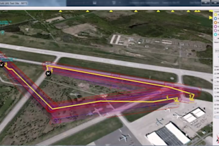
This real-time 3D visualization includes flight path and numerous other data points that are important for pilots to know. (Credit: Screenshot, U-SAFE livestream) Showcasing technology that could help usher in the era of commercial drones, the first phase of New York's 50-mile long drone test corridor took place Thursday at Griffiss International Airport in Rome, New York. Using NASA-led research, the Unmanned Aircraft System Secure Autonomous Flight Environment (U-SAFE) is a five-year program that will provide the infrastructure and resources to integrate drones into low altitude airspace. Drone detection and sensing company Gryphon Sensors is leading the initiative, with help from the Federal Aviation Administration, NASA, New York State, and Griffiss International Airport.Here’s What Went Down Thursday’s tests were all about demonstrating the capabilities of technology for tracking and flying beyond visual line-of-sight. Griffiss airport, one of seven FAA drone test sites, was outfitted with numerous low altitude radars to detect and track drones. Ideally, these systems will allow manned and unmanned aircraft to safely fly in the same airspace. “This is a big deal, that type of instrumentation doesn’t really exist anywhere else in the world,” says Craig Marcinkowski, the company’s business development and strategy director. Three flight and tech simulations were conducted: search-and-rescue, package delivery, and structure inspection. The simulations were shown in real-time using a 3D visualization tool called SAFIRE, which pulls data from the airports radar systems. For the simulated package delivery, SAFIRE showed the drone’s flight path, location, flight path crossings and a multitude of other data points. It also increases the situational awareness of drone pilots.

Here's the view from the multirotor drone taking part in the package delivery simulation. (Credit: Screenshot, U-SAFE livestream)What’s Next Yesterday's demonstration is the first of many. Marcinkowski says the program’s goal over the next 18 months is to design seven scenarios that feature a drone flying out of sight within U-SAFE’s planned corridor. For large-scale, commercial drone delivery and other services, it must be proven that flying beyond a pilot’s line of sight can be safely accomplished. We can also expect to see more progress made toward creating standards for drones. Through another program called NUSTAR, drones will be tested in a mock city to learn how they react in real world environments. Drones are affected by environmental changes, so creating standards will help manufacturers plan for elemental challenges. In addition, New York's Governor Andrew M. Cuomo announced an agreement between NASA and the Northeast UAS Airspace Integration Research Alliance, which formalizes the corridor and NUSTAR partnership. A sky filled with drones whirring from place to place is still far off — regulations will need to be passed before this happens, not to mention the infrastructure and rigorous testing that needs to be hashed out before that — but today's test could pave the way for that drone highway.

1 free article left
Want More? Get unlimited access for as low as $1.99/month

Already a subscriber?

Register or Log In

1 free articleSubscribe
Discover Magazine Logo
Want more?

Keep reading for as low as $1.99!

Subscribe

Already a subscriber?

Register or Log In

More From Discover
Recommendations From Our Store
Shop Now
Stay Curious
Join
Our List

Sign up for our weekly science updates.

 
Subscribe
To The Magazine

Save up to 40% off the cover price when you subscribe to Discover magazine.

Copyright © 2024 Kalmbach Media Co.