Can You Spot the Chinese Nuclear Sub?

Widely available satellite imagery is making governments around the world awfully nervous.

By Sharon Weinberger
Jul 21, 2008 5:00 AMNov 12, 2019 5:39 AM
geoeye1.jpg
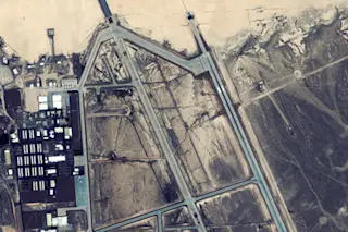
GeoEye captures the notorious Area 51. | Image Courtesy of GeoEye

Newsletter

Sign up for our email newsletter for the latest science news
 

In a generic-looking glass and concrete office building just a few miles from Washington Dulles International Airport, an independent company is—with the full blessing of the government—helping to peel away the last earthly vestiges of cold war secrecy. Unlike Beltway defense companies, where security often starts at the ground floor with guards and gates, GeoEye, one of two U.S. companies selling commercial satellite imagery (the other is DigitalGlobe), is notably open-door until you reach the fourth-floor offices, where a friendly secretary asks, apologetically, whether the visitor is a U.S. citizen.

Inside the company’s headquarters, GeoEye vice president Mark Brender provides a tour of operations. Young engineers in a NASA-style mission control room follow a GeoEye satellite, which is at that moment hurtling around Earth some 423 miles above the ground. Across the hall, GeoEye employees field calls from customers ranging from government agencies to insurance companies. CNN plays continuously on the TV so employees can be alerted to a crisis—a flood, a North Korean nuclear test, a border skirmish—and quickly send orders to the satellite to capture pictures of a specific site.

For a few thousand dollars, pretty much any American can buy up-to-the-moment satellite images of Iran’s nuclear sites, CIA headquarters, even the top secret Air Force testing site, Area 51, in Nevada. Short on cash? If you don’t mind older images, you can view these same sites for free on platforms like Google Earth, the ever-expanding Google service that uses 3-D visualization software to zoom in on different parts of the globe and deliver images to any PC hooked up to the World Wide Web.

This kind of imagery was, for much of the 20th century, part of the eyes-only world of intelligence; from the design of a nuclear submarine to the movement of Israeli troops, one needed high-level clearance for a glimpse. Not anymore. Today, with the advent of civilian satellites here and abroad, we have opened wide the window on places and events that, not so long ago, only spies could see.

Governments around the world have often reacted with outrage to the new age of transparency. And the Pentagon, while hardly thrilled, has had to adjust.

Without a doubt, “the technologies make clandestine operations more difficult to hide and raise the specter of enemies’ having more capability to target critical nodes,” says Theresa Hitchens, a space policy analyst and director of the Washington-based Center for Defense Information.

Yet the expanding field of vision also augurs a unique counterbalance to government excesses of the past. “It improves international security by allowing nongovernmental actors to monitor the actions of nations,” says Hitchens, who points to Amnesty International; that group has launched eyesondarfur.org, a Web site that broadcasts satellite imagery of 12 vulnerable villages in war-torn western Sudan, empowering the public to document atrocities and track the movement of refugees and troops.

For the good and the bad, the lightless world has been illuminated, and the age of transparency is upon us. “The technologies are out of the bag, and governments will not be able to control access everywhere,” Hitchens says. Keith Clarke, a University of California at Santa Barbara geography professor deeply involved in analyzing declassified satellite imagery, agrees. “It’s a lost cause,” he says of government efforts to stanch the flow of sensitive images. “There’s very little that can be done to prevent it now.”

Dawn of an era The imagery we take for granted across our computer screens traces its origins to 1959 and the cold war, when the United States launched a top secret satellite called Corona. Corona’s pair of constantly rotating cameras captured images on film cassettes that were parachuted back to Earth. Since being declassified in 1995, many of Corona’s details have come to light. The earliest Corona images captured objects at a ground resolution of up to 8 meters (about 25 feet), meaning objects on the ground had to be at least that length to be discernible. Although grainy by current standards, the images were still a boon to U.S. intelligence, allowing the United States to look deep into Soviet territory, one time capturing images of a military base that helped dispel the notion of a “missile gap” between the United States and the then U.S.S.R.

Discover's New York headquarters from a satellite. | Image © Google

Corona was just the start. With the development of light-sensitive solid-state chips in the 1970s, the spy community turned to reconnaissance satellites that could dispense with parachutes and beam images to Earth. These so-called electro-optical satellites produced images at resolutions better than 1 meter (about 3 feet)—detailed enough to show individual cars and revealing such secrets as a new Soviet aircraft carrier under construction at a Black Sea shipyard.

The civilian world was also getting into the act, and its most notable early achievement was SPOT, launched by the French in 1986. With 10-meter ground resolution, SPOT was hardly a match for military counterparts, but it was certainly good enough for the press to embrace its images and break news. In one instance, journalists used the images to document the construction of the Soviet Krasnoyarsk radar, an alleged violation of the antiballistic missile treaty, explains nuclear physicist Peter D. Zimmerman, former science adviser for arms control in the U.S. State Department.

By the 1990s foreign countries including France and Russia were offering satellite imagery for sale at increasingly crisp resolutions of up to five meters. A critical turning point, according to Zimmerman, was the Persian Gulf war, when Mark Brender, then a journalist at ABC News, obtained high-resolution satellite images of Kuwait from Russia, and another journalist, Jean Heller of the St. Petersburg Times, made those images public. The revelations were critical: The U.S. government had claimed that Iraq had around 250,000 troops in Kuwait, but the evidence revealed just a fraction of that number.

Some hoped to rein in the imagery and all the associated leaks—but it was a hopeless cause. Today, supported and even encouraged by a U.S. government hoping to sharpen the national edge, companies can sell imagery to private customers here and abroad, though not to what are dubbed “bad actors,” such as Iran. Companies in the United States also cannot sell satellite imagery with a resolution better than about 1.5 feet (0.5 meter), except to the U.S. government. Resolution better than half a meter is “seen as having significant national security value,” explains Kay Weston, who manages the licensing process at the National Oceanic and Atmospheric Administration. “That’s the tipping point.”

The rise of Google Earth

Maintaining even minimal security may be hard because, in the last couple of years, the bad actor clause, the resolution limit, and other protections have been challenged by easy access to Internet services like Google Earth. This open-access technology combines satellite images with even better pictures taken from planes and on the ground. The irony of Google Earth—something not lost on national security agencies—is that the technology itself is a product of government support. In 2003 the National Imagery and Mapping Agency (now known as the National Geospatial-Intelligence Agency) began investing in a new company called Keyhole, which melded satellite imagery and photographs taken from aircraft into a three-dimensional tool for nuanced mapping of all kinds of terrain, including military areas and city streets.

Google bought Keyhole in 2004 and rolled out Keyhole’s software as Google Earth, opening the door to a new set of national security questions. Especially for amateurs, the power of the tool is extraordinary. Once Internet users download the free software, Google Earth enables them to swoop in on their own home simply by entering a street address or GPS coordinates, creating the visual sensation of flying from outer space to a specific point on Earth in a split second. Once you reach the designated site, you can zoom in and out for more or less detail or click on screen buttons that allow you to explore the surrounding area.

Not only is the tool simple to use, but it is available to anyone, anywhere in the world. While U.S. companies must observe government restrictions on selling images to certain countries and individuals, Google Earth just puts the images online, enabling unrestricted access. How then can bad actors be stopped from viewing imagery that they cannot legally buy? According to Weston, some protection accrues from the simple profit motive. “Companies don’t want to give away current imagery for free,” she says. The satellite imagery on Google Earth ranges from a few months to three years in age.

Yet old satellite pictures become more powerful when combined with some of the other free offerings from Google Earth, such as high-resolution aerial photographs (from planes or helicopters). Sometimes such images are freely available directly from the government, and other times they are purchased from private companies that take the photos for a fee. To expand this capability, in 2007 Google bought ImageAmerica, a private company that provides aerial shots. Indeed, while the U.S. government prohibits sale of satellite imagery with ground resolution better than a half-meter, no such rule applies to images from nonsatellite sources. So while a satellite company may be forced to “fuzz up” an image of, say, CIA headquarters in McLean, Virginia, to meet the half-meter standard, that same picture is available in even sharper focus from aerial photographs on Google Earth.

“I worry about the self-delusion factor,” Hitchens says. “It’s almost like willing ourselves to believe no one can see what we’re doing. That’s patently not true.”

The breaches

With the proliferation of online tools, it is hardly surprising that state secrets have been exposed. In a highly public—and embarrassing—incident, a blogger in July 2007 noticed a photo showing a U.S. Navy nuclear submarine in Bangor, Washington, posted on Microsoft-owned Virtual Earth, a Google Earth rival. The problem was not the sub per se, but the sub’s propeller, which was supposed to be covered with a shroud when out of water to protect its top secret design. The propeller was left exposed, and the image was posted online. “They protect those propellers like it’s the body and blood of Christ, the host,” says John Pike, who runs Globalsecurity.org and was one of the first private analysts to buy commercial satellite imagery. “It had been 30 years since anyone had seen an American nuclear submarine propeller.”

Nor is the U.S. government the only one to get caught up in the expanding reach of freely available imagery. Israel, in particular, has fought to control high-resolution imagery of its territory. More than a decade ago, the U.S. Congress passed the Kyl-Bingaman amendment, which prohibits U.S. companies from selling commercial satellite imagery of Israel that is better than similar imagery from other commercial sources; in practice this has meant that imagery of Israel is degraded to two meters, a restriction not imposed on any images of the United States.

In another notable case, a U.S. nuclear expert last year pointed to satellite images that appeared online showing China’s new nuclear ballistic missile submarine. “Both China and India have raised their hackles about imaging satellites and tried to push back,” Hitchens says. Calls by these countries to restrict satellite imagery, if heeded, would be a “scary” precedent, she says.

Some incidents are less about national security than about embarrassment: Bahrain’s royal family briefly fought to block its citizens from viewing Google Earth images of its luxury housing, for fear of personal exposure.

But perhaps the most telling example of how the rapid expansion of mapping technology has caught the Pentagon off guard is the case of Google Street View, a feature Google introduced in 2007 that includes street-level photos providing 360-degree views, allowing users to weave their way through a city. Google collects the pictures for Street View by sending out cars and vans equipped with a special camera that captures the distinctive panoramic images. While Google Street View raised privacy concerns for individuals captured in the images, the novel addition to Google was not something that immediately raised red flags for national security.

Then, in late February, just weeks after returning from his second deployment to Iraq, Colonel James Brown, who heads force protection and mission assurance at U.S. Northern Command in Colorado Springs, received an unexpected message: Was he aware that something called Google Street View had mapped out all the roads at Fort Sam Houston, an Army base in Texas?

Brown wasn’t familiar with Google Street View, so he went online to take a look for himself. There it was: panoramic views of the entire base; you could even zoom in and out on security fences and guards. He recalled thinking to himself, “Oh, my God, this is the best preoperational surveillance tool I’ve ever seen in my life.”

In other words, it was ideal for terrorists planning an attack on the base. “I was aghast,” Brown recalls. “We didn’t have any idea that this existed.” Brown decided he needed to figure out what sort of online images might prove a threat to national security.

At U.S. Northern Command, which was established after 9/11 to defend the homeland, Brown put the critical infrastructure protection team to work, setting them loose on the Internet. “What was funny,” he says, “is that the first night, the answer came back: This is the list of DOD [Department of Defense] facilities that are mapped, and we thought, ‘Oh, boy, this is bad.’” It turned out to be a false alarm; a number of the flagged facilities were military bases that had been decommissioned, so their mapping was not a threat. Brown’s group also looked at photographs of entrances to bases from the outside but decided to let those cases go. “We didn’t want to get involved in trying to pull the wings off photography flies off base,” he says.

In the case of Fort Sam Houston, the panoramic street views ended up being something of a fluke; Google mappers had mistakenly been allowed on base. (Brown says that at the time, base security had seen the street mapping program as innocuous.) Within days of a review, however, U.S. Northern Command issued an order to U.S. bases and facilities instructing them not to allow this in the future. The command also contacted Google, which quickly removed the Street View images of Fort Sam Houston.

The future of I Spy The goal of national security entities has long been to know everything, everywhere, at all times—a concept dubbed “universal situation awareness” by one former Air Force official. Toward that end, technology is advancing at a rapid pace.

State-of-the-art technology still be­longs to the secret world of the intelligence community, and satellite experts familiar with classified technology are hesitant to speculate about precise capabilities. “I don’t believe that the optimal performance of systems we have up there right now is public information,” says Sidney Drell, professor emeritus at the Stanford Linear Accelerator Center, who is credited as one of the fathers of satellite reconnaissance. Outside analysts like Steven Aftergood of the Federation of American Scientists say that a resolution of 10 centimeters—allowing us to see a softball or the fine details of a car from space—is likely the best available resolution using visible light. This limit is imposed by the atmosphere, which diffracts visible light beyond that point.

To gather other kinds of data, meanwhile, some technologies focus on alternate regions of the electromagnetic spectrum, for instance, radar. Radar satellites come equipped with an antenna that sends radio waves to Earth; after hitting the planet’s surface, the signal is reflected and scattered back toward a detector that generates an image without the need for visible light. “You can see day and night and through most weather,” says David Glackin, a remote sensing scientist with the Aerospace Corporation, a federally funded nonprofit research center.

Several nations, including the United States, have already launched radar-imaging satellites, but efforts abound to push the envelope further. One ambitious Air Force project involves a constellation of space-based radar satellites that would surround the planet, providing full coverage with the kind of granular detail thus far available only through aircraft or vehicles on the ground. The idea is to build a reconnaissance net that would target troops and even individuals from second to second, across every square foot of the globe. Gathering so much information has unique requirements, including cameras with huge apertures. The project “got a lot of criticism from academics who showed that the approach wasn’t going to work unless the face of the detector in space was as long as a football field,” says Philip Coyle, the Pentagon’s former top technology tester and a senior adviser to the Center for Defense Information. “Something that huge makes a very big target for an enemy.”

In the meantime, the image resolution of commercial satellites continues to improve. GeoEye’s IKONOS, currently its premier satellite, provides resolution at better than one meter, but the company plans this August to launch GeoEye-1, a polar orbiting satellite equipped with a camera that can capture up to 700,000 square kilometers of black-and-white and 350,000 square kilometers of color imagery a day. The satellite, equipped with GPS, will be able to swivel and point its camera with a ground resolution of 41 centimeters?.

“From 423 miles in space, we’ll be able to see an object the size of home plate on a baseball diamond,” says Brender. “GeoEye-1 will have the best accuracy and resolution of any commercial imaging satellite in the world when it goes up,” says Bill Schuster, GeoEye’s CEO.

For nongovernment customers, however, GeoEye-1 will still have to degrade that high-quality imagery to half a meter. The main barrier for commercial companies like GeoEye and DigitalGlobe, which supplies satellite imagery to Google, is not technology but economics and policy; there’s no point taking sharper pictures if they aren’t allowed to sell them widely. Some of the best future images, meanwhile, may come from foreign competitors focused on increasing satellite resolution themselves. As Glackin points out, in 1980 only five countries were operating imaging satellites. “Today there are 31,” he says.

Transparent planet The advent of Google Earth and related services raises a basic question: Have the images created a security risk? The answer, according to a number of experts, is yes, but there’s not much that can be done about it. It’s not clear that the U.S. government has the authority to remove imagery already in the public domain, according to Aftergood. And the availability of imagery from foreign sources may make some cases moot. “I think the answer probably is case specific, and only exceptional cases could qualify for legal or official intervention,” he suggests.

Attempts to control satellite imagery are “a losing proposition,” agrees Jeffrey Richelson, a senior fellow at the National Security Archive and a longtime expert on satellite reconnaissance. “These capabilities keep improving, and the sources of imagery keep expanding; look at countries that have launched high-resolution commercial imagery satellites over the last years. As that number goes up, it’s difficult to prevent people who want to get images of particular locations from getting them.”

And it is no longer just overhead imagery that is increasingly available. What makes the case of Google Street View and the mapping of Fort Sam Houston unique is precisely that it involved not overhead satellite imagery but rather cameras on the ground, raising more questions about Pentagon control as technology develops faster than the government’s ability—or authority—to regulate it. Colonel Brown, for his part, acknowledges that tension. “What we’re wrestling with is the fact that our technology is developing at such a rapid rate, it is crossing over boundaries we took for granted,” he says.

Some countries may still be battling the onslaught of available imagery, but here in the United States, the Pentagon has realized the futility of de-Googling Earth: Both U.S. Northern Command and the National Geospatial-Intelligence Agency say they don’t actively trawl the Internet looking for images of sensitive U.S. sites, although commercial satellite service could be interrupted if profound risk were perceived. When asked whether GeoEye is prohibited from selling imagery of any sensitive areas, Brender said no. As proof, he e-mailed, in midconversation, a detailed picture of Area 51, showing new construction at the Air Force’s top secret testing facility in Nevada, including new hangars and a lengthened runway.

In the GeoEye conference room in Virginia, Brender flips through slides of imagery depicting the world’s most mapped areas, including conflict hot spots, borders, and cities that are home to millions. These are the places people want to see. Could someone obtain such imagery as part of a terrorist plot? “We are not aware of one instance where our imagery was used for the greater evil,” Brender says.

But even if images were misused, it would not change the trend. We’ve already entered the era of extreme transparency, and given the widespread technology, our clarity of vision can only expand. With the once-shrouded world bathed in so much light, Brender says, it would in the long run be “fruitless to try to hamper how we look at Earth from nonsovereign space.”

De-Googling Yourself: Hide in Plain Sight

It’s not just governments that have problems hiding from the modern panopticon of satellites, aircraft, and ground-based cameras: Private citizens, too, are exposed. “You don’t have exclusive rights to your property from the street or from above,” says UCSB geography professor Keith Clarke. “Anybody who wants can take a photograph of your house. Many groups are doing exactly that.”

So is there a way to hide from the infinite reach of Google Earth? You could choose to live someplace that people don’t usually want to see in high resolution: a rural or sparsely populated area far from urban centers, international borders, and major points of interest. You could live underground, in a subway tunnel or a cave. Even in the suburbs, you could live under a canopy of trees. To avoid having video images of your house popping up on Google Street View, meanwhile, the best protection could be surrounding your property with a very high fence.

Your house is not the only thing that could show up online: Street View captures full-face shots of private citizens who happen to amble into the field of vision of its voracious video cameras. So to keep your face out of the database, stay alert. If you happen to see the telltale mounted videocam of Google Street View (it can be atop any kind of vehicle from a subcompact to a minivan), shield yourself with a sweatshirt hood, a newspaper, or even your hands.

There is one residence on the planet famously obscured by Google Earth: the Naval Observatory, official home of the vice president of the United States. Yet even Dick Cheney can’t escape the long arm of the Internet—a clear image of the Naval Observatory is available on Yahoo.

1 free article left
Want More? Get unlimited access for as low as $1.99/month

Already a subscriber?

Register or Log In

1 free articleSubscribe
Discover Magazine Logo
Want more?

Keep reading for as low as $1.99!

Subscribe

Already a subscriber?

Register or Log In

More From Discover
Recommendations From Our Store
Stay Curious
Join
Our List

Sign up for our weekly science updates.

 
Subscribe
To The Magazine

Save up to 40% off the cover price when you subscribe to Discover magazine.

Copyright © 2024 Kalmbach Media Co.