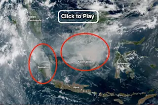
A screenshot of an animation of satellite imagery from the Himawari-8 satellite reveals dense smoke billowing from extensive fires in Kalimantan and Sumatra. Smoke (see circled areas) has a slight color tinge compared to whiter clouds. Click for the animation, which runs from Oct. 14 through the 22nd. (Source: NOAA/RAMMB/Japan Meteorological Agency) Huge swaths of Indonesia are burning, blanketing a wide region in thick palls of smoke that threaten the health of millions of Southeast Asians. So far this year, nearly 110,000 fires have broken out in the island nation (as of Oct. 22), most of them in Kalimantan — the Indonesian portion of the island of Borneo — and Sumatra. Since September, these blazes, most of them in carbon-rich peatlands, "have generated emissions each day exceeding the average daily emissions from all U.S. economic activity," according to the World Resources Institute. Click on the screenshot at the top of ...
Seen from space: the Indonesian fires producing more CO2 each day than the economic activity of the United States
Indonesian fires are raging in Kalimantan and Sumatra, creating thick palls of smoke and worsening air quality across Southeast Asia.
More on Discover
Stay Curious
SubscribeTo The Magazine
Save up to 40% off the cover price when you subscribe to Discover magazine.
Subscribe

