MIT hurricane theorist Kerry Emanuel pioneered a mode of analysis known as hurricane maximum potential intensity theory (MPI theory)--essentially, an equation that can calculate the maximum surface wind speed, and the minimum sea level pressure, achievable by a given hurricane in a given climate. I don't understand in intimate detail all the terms in the equation (which you can read here), but I understand in essence what it does. You might say that it calculates a kind of hurricane speed limit. Obviously, the maximum potential intensity varies by time of year and by area of the globe; but there are a few regions where it is particularly high--and, indeed, where extremely intense hurricanes have been observed. One such area is the Gulf of Mexico; another is the Caribbean. And another still is the region off the eastern coast of the Philippines, where we currently find a powerful supertyphoon that may be on route to becoming the strongest storm yet observed in 2007--Sepat. Here's an image of Sepat's totally cloudless eye:

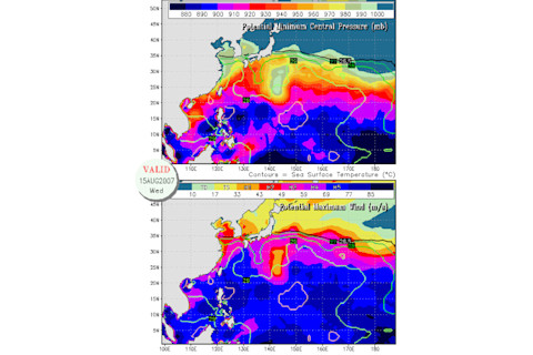
And here's an image of Emanuel's real-time maximum potential intensity map for the region (click for higher resolution). In it, you can see the area of dark blue/black off the Philippines where, sure enough, this storm is currently located. According to Emanuel's theory, a storm here--today--can potentially achieve a pressure lower than 890 millibars and a maximum sustained surface wind speed in the range of 77-85 meters per second (roughly 172-190 miles per hour).

There's no telling yet how intense Sepat will get. Currently the storm has maximum sustained winds of about 150 miles per hour, according to the Joint Typhoon Warning Center. The only pressure estimate I've seen currently gives 916.5 millibars. But the storm is expected to intensify further; and in light of Emanuel's theory, certainly seems to have some serious potential to become considerably more powerful than it currently is...not just a weak Category 5, but a very strong one.


