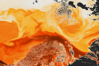
The Gulf Stream, as imaged in the infrared by NASA's Suomi NPP satellite. (Image: NASA & NOAA's Environmental Visualization Laboratory) Who knew the Gulf Stream looked like this — from space or anywhere else? The image was produced on April 16 by NASA's Suomi NPP satellite. It depicts the true complexity of what is often called a river a warm water that delivers heat from south to north in the Atlantic, and across the ocean to Europe. To my eyes, "river" is simply a misnomer. The infra-red image, covering an area about 180 miles east of Atlantic City, New Jersey, shows the warmest waters in dark orange. The National Oceanic and Atmospheric Administration says the temperature of these waters is an astounding 86 degrees F. Lighter colors indicate cooler waters, as low as 50 degrees. And the black areas in the image are clouds. The details of the complex ocean ...
Satellite Psychedelia
Explore the stunning Gulf Stream infrared image captured by NASA's Suomi NPP satellite, showcasing ocean dynamics and warm water rivers.
More on Discover
Stay Curious
SubscribeTo The Magazine
Save up to 40% off the cover price when you subscribe to Discover magazine.
Subscribe

