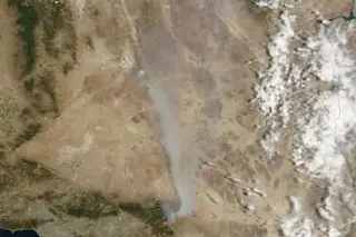
NASA's Aqua satellite acquired this image of smoke from the Lake fire streaming north on June 25, 2015. The fire was burning in southern California in San Bernardino National Forest. The Los Angeles basin is to the left of the red outlines, which indicate hot spots where MODIS detected unusually warm surface temperatures associated with fire activity. (Source: NASA Earth Observatory) |Please see the update below about questions that have been raised about whether this was truly a hobbyist's drone.| I check in at NASA's fabulous Earth Observatory web site almost every day, because I know I'll be treated to spectacular imagery and also learn something new. Today was no different, except this time instead of being edified I wound up getting enraged. Along with publishing the image of Southern California's Lake Fire above, the folks at the Earth Observatory noted this:
Hobbyist drones have hampered firefighting efforts and contributed ...


