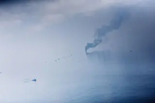
Flying 1,500 feet above the site of the Deepwater Horizon’s explosive oil-well rupture, I found the apparent peacefulness unnerving. I expected swarms of ships and oil-siphoning machines frantically waging war against the tarry sludge. But from my vantage, all I could see was a handful of small boats dragging booms across the water’s surface, dwarfed against a massive backdrop of oily water; also visible were one ship burning gases rising from the blowout and two platforms where relief wells were being drilled. Inside my plane’s cabin, a GPS navigation map in the cockpit flashed “Site of Natural Disaster.” Although the rust-colored slick stretched for miles in all directions, I saw no crews sweeping the ocean between ground zero and Queen Bess Island, a tiny pelican rookery surrounded by bright orange booms.
On land, however, I watched a frenzy of activity as locals prepared to deal with tainted marshes, sickened fish, ...


