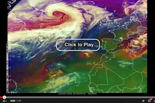
Screenshot of a video showing satellite views of the evolution of two large storms in the North Atlantic Ocean. (Source: National Weather Service) Back on Feb. 24th, I posted a video based on satellite data showing a low pressure system in the North Atlantic evolving into a hurricane-force storm. I guess when it rains it, uhm, pours... In the past few days, not one but TWO big storms with hurricane-strength winds have swirled in the North Atlantic. Click the image above to see a video of the storms just released by the Ocean Prediction Center of the National Weather Service. The data for the video come from the infrared and water vapor channels of the Meteosat Second Generation satellite, and the false color scheme used here is particularly good at showing the rapid evolution of cyclones. The video also shows what the weather service calls "pseudo-natural color imagery" produced by ...
Watch Not One But TWO Huge Hurricane Strength Storms Swirling in the North Atlantic
Discover the latest North Atlantic storms with hurricane force winds captured by advanced satellite views.
More on Discover
Stay Curious
SubscribeTo The Magazine
Save up to 40% off the cover price when you subscribe to Discover magazine.
Subscribe


