Waiting for El Niño: Is he finally getting ready to blast North America?

ImaGeo iconImaGeo
By Tom Yulsman
Nov 8, 2015 8:10 AMNov 20, 2019 3:12 AM
Screenshot_11_7_15_4_41_PM-1024x762.jpg

Newsletter

Sign up for our email newsletter for the latest science news
 

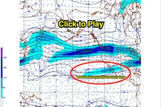
A screenshot from the jet stream forecast for November 7th through the 23rd, as calculated by the GFS model. Watch for a strengthening of the subtropical jet over the Pacific Ocean off the Baja Peninsula, extending across Mexico and up into the southern tier of the United States. Strengthening of the subtropical jet stream in this area is typical during a strong El Niño. (Source: NCEP/NWS/NOAA) Waiting for El Niño hasn't exactly been like waiting for Godot. Even so, it sure feels like we've been waiting awhile for the predicted weather impacts to show up unequivocally. Well, we may not have to wait that much longer.

El Niño's impacts across North America For the United States, El Niño's impacts typically arrive on a strengthening of the subtropical jet stream, a phenomenon that tends to sweep Pacific storm systems on a more southerly track than normal — across Southern California, and then the southern tier of the United States. And if the GFS weather model is right, that strengthening is about to take shape. Take a look at the screenshot at the top of this post to see where this strengthening typically happens. Then click on it to watch a video showing the forecast evolution of winds at the height of the jet stream in the atmosphere between Nov. 7 and 23rd. See that lengthening stripe of blue out over the Pacific off the coast of the Baja Peninsula, extending across Mexico and up into the U.S. southern tier of states? That sure looks like a strengthening of the subtropical jet stream to me. (At the same time, there's still that stronger branch to the north. Ain't weather fun?) I'm a science journalist (and a journalism professor at the University of Colorado), not a meteorologist. So I thought I'd dig a little deeper to reassure myself that I'm actually on to something. And here's what I came up with:

The average strength of jet stream winds between November and February compared to the same months during the strong 1997/1998 El Niño. Note the strengthening west of Baja in 1997/1998. (Data: NOAA/ESRL. Animation: Tom Yulsman) In this animation, the first frame shows the average strength of jet stream winds between the beginning of November and end of February — when El Niño is not a factor. The second frame shows the winds in the same months during the strong El Niño of 1997 and 1998. When there is no El Niño, we've got a strong jet off Japan, but then it peters out east of the International Dateline. During the 1997/1998 El Niño, the subtropical jet strengthens significantly east of the dateline. This strengthening helped sweep storms into California and across the U.S. southern tier, just as predicted. Is the same thing about to happen? If I were a gambling man, I'd double down on that bet. But this is weather, which means surprises could definitely be in the offing. So stay tuned...

1 free article left
Want More? Get unlimited access for as low as $1.99/month

Already a subscriber?

Register or Log In

1 free articleSubscribe
Discover Magazine Logo
Want more?

Keep reading for as low as $1.99!

Subscribe

Already a subscriber?

Register or Log In

More From Discover
Recommendations From Our Store
Stay Curious
Join
Our List

Sign up for our weekly science updates.

 
Subscribe
To The Magazine

Save up to 40% off the cover price when you subscribe to Discover magazine.

Copyright © 2024 Kalmbach Media Co.