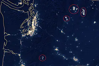
A nighttime image of most of Washington state acquired on August 19 by the Visible Infrared Imaging Radiometer Suite (VIIRS) sensor on the Suomi NPP satellite. Wildfires are circled in red. (Cropped and annotated version of an image from NASA's Earth Observatory.) Wildfires are burning hot and bright across portions of the Western United States — so much so that their glow is visible from space. The image above was captured by the VIIRS instrument on the Suomi NPP satellite early in the morning of Aug. 19, 2015. The lights of the city of Seattle glow brightly toward the left side of the image. To the south, in the lower left corner of the frame, is Portland Oregon. Just as bright is the glow from four raging wildfire complexes, which I've circled in red.
SEE ALSO: Wildfire Smoke Drifts Across 1,000 Miles of the West
To get yourself oriented, have ...


