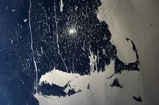
In a photograph captured from the International Space Station, New York City and Long Island stretch along the bottom and Cape Cod juts out to the right. (Source: Astronauts of the International Space Station/NASA) I thought I'd share some sweet eye candy to help ease us into the weekend — a photograph shot from the International Space Station in mid-April showing the glacially carved and etched landscape of the Northeastern United States. Evidence of the role of moving glacial ice is readily apparent. Stretching along the bottom of the photograph, Long Island is essentially an elongated mound of rubble pushed down from the north by the Laurentide Ice Sheet of the last ice age. It marks the farthest advance of the ice sheet about 22,000 years ago. Follow Long Island from the left to the right, and let your eyes keep going. Toward the bottom right you'll find two island: ...
The Northeastern U.S.: Carved and Etched by Glaciers; Painted by Sunlight
Discover an International Space Station photograph showcasing glacial landscapes of Long Island and Cape Cod in stunning detail.
More on Discover
Stay Curious
SubscribeTo The Magazine
Save up to 40% off the cover price when you subscribe to Discover magazine.
Subscribe

