Stay Curious

SIGN UP FOR OUR WEEKLY NEWSLETTER AND UNLOCK ONE MORE ARTICLE FOR FREE.

Sign Up

VIEW OUR Privacy Policy


Discover Magazine Logo

WANT MORE? KEEP READING FOR AS LOW AS $1.99!

Subscribe

ALREADY A SUBSCRIBER?

FIND MY SUBSCRIPTION
Advertisement

Striking Views From Space Reveal the Ferocity and Wide Scope of Canadian Wildfires

It's already been a record-setting year in Canada. What role is climate change playing?

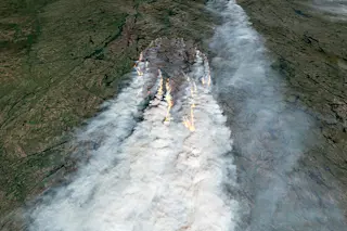
A view from space of a wildfire raging in Canada's Northwest Territories on July 13, 2023, acquired by the Sentinel 2 satellite.Credit: Modified Copernicus Sentinel data processed by Tom Yulsman

Newsletter

Sign up for our email newsletter for the latest science news

Sign Up

In this summer of continuing extreme weather and devastating impacts, Canada has been particularly hard hit.

As of Sunday, July 16, 881 wildfires were blazing there, according to data from the Canadian Interagency Forest Fire Centre. Since the start of the year, 4,157 fires have burned across nearly 39,000 square miles of land — an area slightly bigger than the State of Maine.

That tally of torching — the result of a continuing combination of unusual heat, drought, and dry lightning — has already blown away the record for most land burned in a year in Canada. It's also about 4.5 times the annual average of land burned there between 1983 and 2022 — and much of the wildfire season is still yet to come.

Satellites have been providing both broad-scale and close-up views of the fires, driving home both their scope and ferocity. The image at the top of ...

Stay Curious

JoinOur List

Sign up for our weekly science updates

View our Privacy Policy

SubscribeTo The Magazine

Save up to 40% off the cover price when you subscribe to Discover magazine.

Subscribe
Advertisement

0 Free Articles