On the Edge Redux

ImaGeo iconImaGeo
By Tom Yulsman
Apr 25, 2013 7:30 PMNov 20, 2019 5:07 AM
Sea-Ice-Edge-1024x1024.jpeg

Newsletter

Sign up for our email newsletter for the latest science news
 

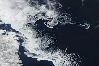
An image captured by NASA's Aqua satellite reveals swirls of sea ice off Newfoundland on April 24, 2013. (Image: NASA) Earlier this month, I posted a satellite image showing the filagreed edge of sea ice between Canada and Greenland. Here's another one, this one off the coast of Labrador. The swirling eddies and filaments reflect movement of water associated with the cold Labrador Current, which flows south from the Arctic Ocean, along with upwelling of water driven by winds blowing across the surface, and differences in ocean temperature and salinity. As seen from space, the tracery at the melting edge of sea ice is beautiful. From an airplane, it can appear downright dramatic, as seen in this photograph of gigantic icy whirlpools just east of Labrador's Belle Isle:

Sea ice swirls in the Labrador Current on April 8, 2008, as seen from a flight from London to Chicago. (Image: Courtesy Daniel Schwen) The extent of sea ice off Labrador yesterday was roughly equal to the median extent between 1979 and 2000, according to the daily update from the National Snow and Ice Data Center. But overall, the extent of Arctic sea ice is below the long-term average.

1 free article left
Want More? Get unlimited access for as low as $1.99/month

Already a subscriber?

Register or Log In

1 free articleSubscribe
Discover Magazine Logo
Want more?

Keep reading for as low as $1.99!

Subscribe

Already a subscriber?

Register or Log In

More From Discover
Recommendations From Our Store
Shop Now
Stay Curious
Join
Our List

Sign up for our weekly science updates.

 
Subscribe
To The Magazine

Save up to 40% off the cover price when you subscribe to Discover magazine.

Copyright © 2024 Kalmbach Media Co.