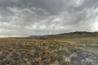
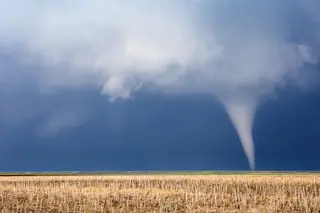
Roiling clouds build up along Colorado's Front Range just north of Boulder on April 8 as a potent spring snowstorm sped toward the region. This afternoon, it was almost t-shirt weather here in the Boulder, Colorado area, with temperatures in the 60s. Then, within the span of a just an hour or so, it all changed. Menacing clouds built up, temperatures plunged by 20 degrees, and a vicious wind gusting to what seemed to be over 30 miles per hour kicked up think palls of dust. I shot the photo above at about 4:30 p.m. Mountain Daylight Time north of the city, just as the excitement was beginning. More about the storm in a minute, but the image itself is worth commenting on. It's actually a mosaic of 16 separate photographs shot with my iPhone and stitched almost seamlessly together by an awesome app called "Autostitch." I then imported the mosaic into Aperture, which I used to tweak the overall image just a little, adding some definition in the clouds, and adjusting the tonal curves to more closely approximate how the scene is visible to the eye. I hope you like the result. (I'll tell you that with the wind gusting so hard, it became very difficult to open the door to my car to get back in!) As I write this at about 8 p.m., it has just started to rain. An Arctic cold front plunging down from the north will drop temperatures below freezing soon. Snow is forecast to start after 9 p.m. Meanwhile, to my east, dangerous thunderstorms erupted in the unstable airmass — and a tornado warning was in effect until just a few minutes ago. I think this is a first in my personal experience: possible tornados ahead of a big snowstorm in April. The source of this meteorological brou ha ha is a low pressure system swirling near the Four Corners, a big southward dip in the jet stream, that Arctic air mass plunging southward, and moisture streaming in from the Pacific (and possibly the Gulf of Mexico too). You can see the source of that Pacific moisture here:
An animation of total precipitable water in the western Pacific April 6-8. (Image: CIMSS. http://tropic.ssec.wisc.edu/) The image is based on data from microwave sensors on polar-orbiting satellites. It shows "total precipitable water" — water vapor from the surface of the Earth to the top of the atmosphere. In the animation you can see the west coast of California getting hosed by water vapor, some of which is now entrained in the storm that's getting ready to bring a return to winter here in Colorado. After plastering us, the snow is forecast to move up into South Dakota, Minnesota and even Wisconsin and Michigan. Meanwhile, that southward dip in the jet stream will work its way East, bringing up moisture from the Gulf and triggering an outbreak of severe weather, including possible tornados, in a big swath of the nation's mid-section. Okay, enough weather weenie stuff for now. Time to hunker down...