Stay Curious

SIGN UP FOR OUR WEEKLY NEWSLETTER AND UNLOCK ONE MORE ARTICLE FOR FREE.

Sign Up

VIEW OUR Privacy Policy


Discover Magazine Logo

WANT MORE? KEEP READING FOR AS LOW AS $1.99!

Subscribe

ALREADY A SUBSCRIBER?

FIND MY SUBSCRIPTION
Advertisement

A Pandemic of Wildfire, Part 1

Images from space reveal the scope and intensity of 2020's burning season — from Siberia to the western United States.

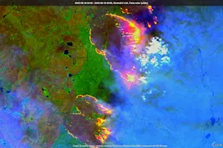
The Sentinel 2 satellite captured this image of wildfires raging in Russia's Sakha Republic on Aug. 18, 2020.Credit: Copernicus Sentinel data, processed by Tom Yulsman using Sentinel Hub EO Browser

Newsletter

Sign up for our email newsletter for the latest science news

Sign Up

The blaze captured in the false-color satellite image above is just one small part of a much bigger wildfire, which is just one among hundreds that have scorched Siberia since winter ice and snow melted in May.

Meanwhile, half a world away, a brutally hot August in the western United States has fueled vicious fires in California, as well as in my own state of Colorado. In this post, and a Part 2 to follow, I'll share some remarkable remote sensing imagery of what I think is fair to call a pandemic of wildfire.

When the Sentinel 2 satellite flew over the intense Siberian wildfire above on Aug. 18, 2020, it was torching new territory on the eastern side of a wildfire complex that was twice the size of New York City. (For a bigger, better version of the image, go here.)

The Sentinel 2 satellite captured this false-color image ...

Stay Curious

JoinOur List

Sign up for our weekly science updates

View our Privacy Policy

SubscribeTo The Magazine

Save up to 40% off the cover price when you subscribe to Discover magazine.

Subscribe
Advertisement

0 Free Articles