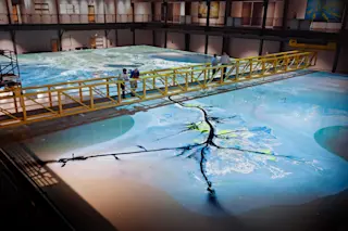
In a cavernous building in Baton Rouge, Louisiana, just steps from the Mississippi River, environmental engineer Clint Willson lifts a beaker filled with dark plastic crumbs. They look like black lava salt, but in this room, the granules are a stand-in for river sediment. The tiny particles are an essential part of the massive Lower Mississippi River Physical Model: a working, flowing simulation of the river.
The model, bigger than two basketball courts — with bleachers — elicits gasps from first-time visitors. Carved into the surface of a huge white table is a precise re-creation of 14,000 square miles of southeastern Louisiana, gleaned from more than 4 billion data points. A deep winding channel crosses the entire model, representing 179 miles of the mighty Mississippi from just south of Baton Rouge to the delta. Projectors beam satellite views onto the table, turning the white surface into a photorealistic replica of ...


