Whatever you learned in school about how our species spread across the planet is wrong.
For decades, textbooks taught that humans left our ancestral African homeland and spread across the world via the landmasses we know today, reaching Australia less than 50,000 years ago and the Americas a mere 13,500 years ago. But there’s a continent-sized gap in our knowledge about our collective past that scientists are only now starting to fill in.
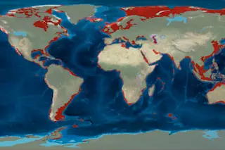
From the North Sea to the island-dotted tropics between Asia and Australia, from the frigid waters of the Bering Strait to the sunny Arabian Peninsula, now-submerged coastal landscapes were exposed and accessible to our ancestors at multiple times in prehistory, including key periods of human expansion across the globe. The square mileage of these areas now under the seas is equal to that of modern North America.
“My own view is that there are certainly sites out there,” says University of York archaeologist Geoff Bailey. “Some of the areas [that would have been] most attractive to humans are now underwater.”
Long out of scientists’ reach, these submerged landscapes, which some researchers collectively call Aquaterra, are finally emerging from beneath the waves — at least figuratively. Thanks to cutting-edge technologies and increasing evidence that the old models of early human dispersal no longer make sense, several projects are underway to reconstruct these ancient worlds and search for evidence that will likely rewrite the human story.
Sea Change
The first members of the genus Homo emerged at roughly the dawn of the Pleistocene, which began about 2.6 million years ago and ended with the final drips of the last great glacial melt, about 12,000 years ago. It is, essentially, the epoch of human evolution. By its end, only one species of human remained — us — and we had settled and thrived on every continent except Antarctica.
For 95 percent of the time that humans have existed, sea levels have been lower than they are now, usually by about 130 feet. At their lowest, they were about 400 feet lower, globally, than they are today.
These dramatic shifts in sea level occurred during the Pleistocene, during which the world seesawed between multiple glacial maxima, when much of the world’s water was locked up in massive ice sheets, and interglacial periods, when the ice melted and inundated low-lying continental shelf edges.
Many researchers refer to these now-flooded lowlands by their regional names, such as Beringia, which once connected Siberia with Alaska. But retired University of Kansas geographer Jerome Dobson has led a crusade for two decades to give these lost lands a single name, Aquaterra, to underscore their significance to the human story.
Just as today’s human populations cluster along coastlines — nearly half of us globally live within an hour of a coast — our ancestors likely did as well. These lost regions are not merely stretches of continental shelf now underwater, but rather resource-rich ecosystems and corridors once used for exploration by early humans.
“If you look at the factors that drove our evolution, a lot of them were coastal,” Dobson says. For example, the richest sources of the element iodine — essential for our thyroids to function — are fish, seaweed and shellfish. “Iodine is a coastal resource,” he says. “We have to have it to survive. We’re dependent on it.”
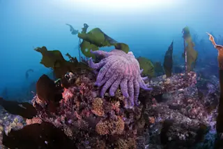
Hunters and foragers on the coasts would have enjoyed the best of both worlds, terrestrial and marine, with access to fresh water, land animals and plants as well as shellfish, seaweed, seabirds and fish.
The appeal of coastal living is not just limited to humans, either. “If you look at ecological data for mammals, both herbivores and carnivores occur in greater densities in coastal regions,” says Bailey.
He adds that glacial maxima, when ice sheets were expansive and sea levels fell, typically meant global shifts to a drier climate that could have made inland areas less habitable.
“During periods of lower sea levels, those coastal regions would have been particularly attractive because they generally coincide with periods of greater aridity in the hinterlands,” Bailey says.
Paradigm Shift
Naturalists and other curious proto-scientists recorded archaeological sites at or near the shoreline as early as the 18th century. A handful of researchers in the mid- to late 20th century employed seabed survey methods developed for offshore oil and gas exploration, but results were modest.
For a long time, Bailey says, few people bothered with underwater exploration of submerged coastal areas because “it would have been too difficult with a very low prospect of finding anything.”
It’s only recently that systematic, high-resolution study of Aquaterra has become possible, thanks to newer technology such as lidar bathymetry, which uses laser pulses fired overhead from drones or planes to create high resolution maps of seafloors in shallow waters.
Research into paleocoastlines was also long hampered by cost, but more projects are partnering with offshore gas and mining exploration companies, piggybacking on their survey expeditions.
“There’s been a huge explosion of people exploring the seabed, mainly for commercial reasons. It opened up possibilities,” says Bailey, adding that more and more, governments require offshore archaeological assessments when signing off on development projects.
Paleocoastline research logistics have improved, but the mindset of some in the field hasn’t evolved. A bias remains against the idea that early humans were advanced enough to use coastal resources, including traveling by boat.
“There is still a deep-rooted belief, even today, that there is a ladder of progress in human evolution, and that seafaring and use of marine resources is a very high, very late rung on that ladder,” Bailey says.
Many younger researchers, however, are more open-minded about early seafaring. While still a graduate student, Shimona Kealy, an archaeologist and paleontologist at Australian National University, found new evidence for a possible route for early humans to have reached Australia by about 65,000 years ago. Much of their travel would have been by sea, both island-hopping and crossing significant distances with strong currents.
“I think resistance to the degree of maritime technology early humans may have had comes from sitting in your office in Europe, thinking Captain Cook didn’t find Australia until the 1700s, so it must take a tremendous amount of courage and bravery to head out to sea,” quips Kealy.
“You have to step back,” she says, drawing on her own experience working in Indonesia to imagine early human explorers. “These people are growing up, and their culture is developing, on an island archipelago where, most of the time, you can see across to at least one island. Being there and doing fieldwork there makes you realize how interconnected this area is.”
Needles in a Haystack
The challenges of logistics and overcoming the field’s lingering terrestrial bias pale in comparison to the power of nature. Finding evidence of early human coastal dispersal is no day at the beach.
“Half the battle in underwater work is understanding where you should look within thousands of miles of landscape,” says Amy Gusick, an archaeologist at the Natural History Museum of Los Angeles County who has led underwater expeditions in Mexico and the U.S.
“In underwater research, you have to understand sea level rise, the cultural or historical context and also what kinds of sites you’re looking for,” Gusick says. Shellfish foragers are likely to leave different evidence at different kinds of sites, for example, than mammoth hunters.
Plus, says Gusick, “you have to make sure you’re looking in areas that have some chance of preservation.” Off the California coast, for instance, “large portions [of continental shelf] have been annihilated by wave action and tidal force.”
Along the Canadian Pacific coast, the sheer weight of the ice sheets pressed landmasses down during glacial maxima. As the ice melted, the land sprang back up unevenly — a phenomenon known as isostatic rebound. In some highly localized areas of British Columbia, for example, Pleistocene sea levels are actually several feet above the current shoreline. Add to that a host of other forces that shape our world — such as seismic activity, wind erosion and sediment buildup — and the complexity of re-creating paleocoastlines becomes clear.
Now imagine you’re not only trying to locate these landscapes — you’re also looking for signs of small bands of humans, traveling with no more than what they could carry.
“The people would have been hunter-gatherers, foragers, people in exploration and colonization mode,” says University of Oregon archaeologist Jon Erlandson.
Engaging Your Core
To find evidence of a human presence, researchers begin not by looking for evidence of people, but by reconstructing the environment these early explorers would have encountered.
“We’re not on a treasure hunt,” says Todd Braje, an archaeologist at the California Academy of Sciences who is working with Gusick, Erlandson and colleagues on a project in the Channel Islands off Southern California. “We are mapping and sampling paleolandscapes. ... Once we’re able to predict landforms, the soil, the ecology, we’ll start to have success identifying potential archaeological sites.”
A paleocoastline research project often starts by developing a customizable digital map from existing seafloor maps. The new maps can highlight data specific to the project’s focus, such as identifying sediment buried below the seafloor that could indicate the course of a long-extinct river.
Researchers use these maps to zero in on areas of interest. They then use different imaging tools to show both the seafloor and what’s beneath it on an ever-finer scale. Depending on depth and conditions, the team might also deploy remote sensing equipment or divers to refine their understanding of the specific location.
Coring is often the next step, when researchers sample layers of ancient soils, or paleosols, that were subsequently buried by marine sediments as the sea levels rose.
Paleosols are typically full of pollen and microfossils of simple organisms, such as diatoms, a kind of algae that can indicate climate conditions. The paleosols may even preserve sedimentary DNA shed from ancient organisms. Identifying what flora and fauna were present at the site can help researchers reconstruct the environment and determine whether it might have been attractive to human hunter-gatherers on the move.
Shell Game
An armchair archaeologist raised on myths of Atlantis and Indiana Jones movies might be disappointed to learn that researchers have more modest hopes for an Aquaterra find. We’re talking shell middens.
These heaps of discarded shells exist the world over, sometimes the result of natural processes such as tidal deposition or collection by birds — and sometimes the work of humans. Bailey, who is researching massive ancient shell middens on islands in the Red Sea, says the piles can record a surprising amount of information about coastlines, climates and the presence of even small groups of humans. “You don’t have to eat many oysters to have a big pile of shells,” he says. It’s also possible that individuals processing the shellfish, removing the edible portions and tossing the shells, may have left behind stone tools and other artifacts that confirm a human presence. Other materials that might be found at Aquaterra sites include organic matter such as seeds, fibers and even wood. Fish and other animal bones are also likely to survive, potentially preserving clues to the early humans’ diets. As additional international projects get underway this year to bring Aquaterra to the surface, researchers involved in the work are united in their optimism about the field’s growing momentum. “This is really an exciting time,” Braje says of the new focus on paleocoastlines in the human story. “Twenty or 30 years ago, the questions we’re asking now would have been career suicide because we had that [terrestrial bias] paradigm. Things have fundamentally changed. It’s blown wide open.” Erlandson agrees: “Over a 40-year career it’s been amazing to see a 180-degree shift. Now there’s a broader understanding of humans and our deep connection to the sea.”
A New Way Out of Africa
70,000-plus years ago
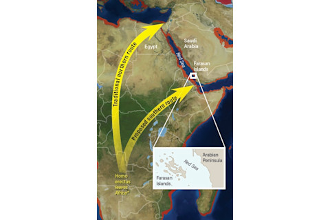
Early humans may have island-hopped across the southern end of the Red Sea. Researchers are searching for evidence near Saudi Arabia’s Farasan Islands. (Illustrative only; actual starting point unknown; Credit: Deep Time Maps/Alison Mackey/Discover)
Deep Time Maps/Alison Mackey/Discover
Our ancestors, such as Homo erectus, began leaving Africa and moving into Eurasia by about 1.9 million years ago. Subsequent waves of dispersal, eventually including our own species, followed.
The timing and route of this travel out of Africa has been murky due to a lack of archaeological sites. Perhaps that’s because, for decades, researchers focused on a route out of Africa from what’s now Egypt, migrating along the eastern Mediterranean coast into the Middle East.
A route across the southern end of the Red Sea, from the East African coast to the Arabian Peninsula, would not have been possible, conventional thinking went, because it would have required crossing a strait about 20 miles wide at its narrowest point.
But recent genetic analysis of baboons living on either side of the strait showed that the animals managed to cross the Red Sea at least twice in the last 150,000 years. New paleocoastline reconstructions have shown that, at lower sea level, islands emerged mid-channel. It would have been possible to island-hop across the strait, with the widest stretch of open water measuring little more than 2 miles. If baboons could manage it, why not archaic humans?
Archaeologist Geoff Bailey, at the University of York, is currently working on a research project focused on a small group of southern Red Sea islands off the coast of Saudi Arabia. The Farasans are home to thousands of shell middens. These piles of waste from processing seafood can be so large they can be seen from space. The oldest of these middens were created about 7,000 years ago. During times of lower sea level, Bailey believes early human explorers leaving Africa may have left shell middens of their own. If they can be found beneath layers of accumulated sediment, they may provide evidence for the timing and route of our species’ journey out of Africa — and perhaps even earlier dispersals.
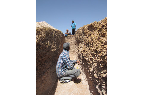
On the Farasan Islands, the research team working with Geoff Bailey examines the interior of a shell midden after digging a narrow trench into it. Whether natural or made by humans, these middens can reveal a lot about ancient coasts. (Credit: Courtesy of Geoff Bailey/University of York)
Courtesy of Geoff Bailey/University of York
Bailey’s team is modifying a type of seismic survey, originally developed for oil exploration, to search for clues below the seabed surface.
“We’re experimenting to identify the acoustic signature of a shell midden under marine sediment,” he says. He admits the methodology is new and still being refined — and that, even if perfected, it might not find anything.
"We are sticking our neck out there. We don’t know what we’re going to find,” he says. “In archaeology, you don’t know what you’re going to find until you find it.”
Dispersals Down Under
65,000 years ago
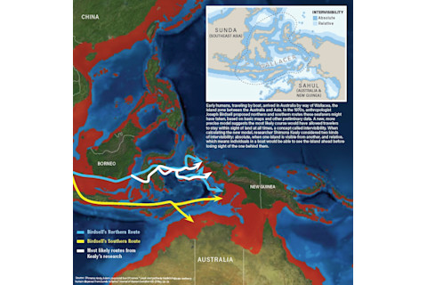
(Credits: Map, Deep Time Maps/Alison Mackey/Discover; Inset, Alison Mackey/Discover after Kealy et al. 2018)
Aquaterra, even at its largest, would not have let the First Australians keep their feet dry. The extended landmasses of Sunda (modern Southeast Asia) and Sahul (today’s Australia and New Guinea) have never been connected. Reaching Australia required seafaring skills, navigating boats through strong currents and Wallacea, a transitional zone of islands.
Named for British naturalist Alfred Russel Wallace, who described it in the mid-19th century, the islands of Wallacea were never connected to either Sunda or Sahul. Animals found in Sunda, to the west, may have made it to Wallacea, but most never expanded beyond it to Sahul in the east. Among mammals, there are just two exceptions: rodents and humans.
More than 40 years ago, anthropologist Joseph Birdsell attempted to find the most likely path of human migration across Wallacea and into Australia. He came up with two routes, northern and southern, using basic paleoenvironmental reconstructions. For decades afterward, researchers focused on the route that skirted the southern edge of the region, believing it was the more plausible of the two.
But Shimona Kealy, a researcher at Australian National University, used more precise, modern map technology and improved Pleistocene sea level records to look at the potential routes. She also incorporated updated models of intervisibility: where early seafarers were able to see from one island to the next. Published in 2018 in the Journal of Human Evolution, her research found that the northern route would have been more likely, and that, amid fluctuating sea levels, it would have been easiest to travel by boat about 65,000 years ago.
The timing of the possible northern route is crucial because, in 2017, other researchers dating thousands of artifacts at the northern Australian site of Madjedbebe reported in Nature that the materials were up to 65,000 years old.
The Madjedbebe dates are controversial because many researchers believe that humans did not arrive in Australia until 45,000 to 50,000 years ago. Kealy thinks the consensus will change as more sites on the continent are dated using newer, more precise methods, but her focus remains on Wallacea.
“People were in the region at that time [65,000 years ago],” she says. “There’s a likelihood of them being in Australia by that time, too.”
She’s now working with Australian and Indonesian colleagues on a new, three-year project to search for early archaeological sites on islands along the proposed northern route.
Meanwhile, on the Dampier Islands off the northwestern coast of Australia, Bailey and colleagues have begun the first systematic exploration of Australia’s submerged paleocoast.
Their plan, outlined in 2018 in the journal Antiquity, is divided between reconstructing submerged features, such as rivers and lake basins, and reviewing previously documented onshore sites.
“[We] look at onshore archaeology to think about what sort of locations would have been attractive to them,” says Bailey. “There are often very specific features, such as raw materials for stone tools, fresh water, or a good place to ambush animals. . . . You use that model to help refine your understanding of targets to home in on underwater.”
Two particularly promising targets: carved rock art already found at multiple onshore sites, and stone weirs, or fish traps. Both could be spotted in new, higher-resolution seafloor maps the team is creating.
Riding a Kelp Highway: The First Americans
15,000-plus years ago
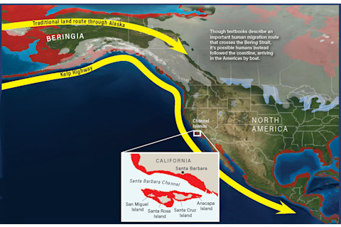
California’s Channel Islands would have been different 16,000 years ago, when sea levels were 330 feet lower than they are today. The four northern islands would have been a single landmass (shown above in red). (Credits: Map, Deep Time Maps/Alison Mackey/Discover; inset map, Alison Mackey/Discover after USGS)
The conventional view of the first humans to reach the Americas is that they arrived from Siberia, bundled in furs and tromping across the steppes of Beringia, no more than 13,500 years ago. After crossing the land bridge, they followed an open corridor between two shrinking ice sheets into the continent’s interior.
But recent geological and paleoenvironmental studies, such as a reconstruction of ice sheet ebb and flow published in Science in 2017, have suggested that this corridor would not have been habitable until centuries later, long after humans were already present throughout the Americas. Plus, sites from Chile to Florida have been dated as at least 14,500 years old.
First proposed about a decade ago by University of Oregon archaeologist Jon Erlandson, the Kelp Highway Hypothesis suggests that, millennia before the inland Beringia land corridor opened, humans could have followed resource-rich paleocoastlines by boat. This route would have taken them from Asia and Siberia eastward along the southern coast of Beringia, into the Americas, and all the way to southern Chile. The idea is gaining momentum.
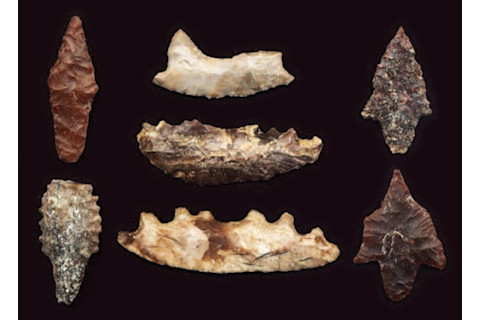
These 12,000-year-old projectile points and crescent-shaped knives are examples of the kinds of artifacts left behind by early explorers of the Channel Islands. (Credit: Jon Erlandson)
Jon Erlandson
“We’ve been talking about the ice-free corridor for 80 years,” says Todd Braje, California Academy of Sciences archaeologist who believes a coastal route was open at least 16,000 years ago and possibly much earlier. “It is time to explore other things.”
Part of the problem with investigating a maritime route along Beringia’s southern coast is the extreme environment of the region today. Even in the best weather, Arctic regions are limited to very short (and expensive) field seasons.
Several groups of researchers are looking instead at areas along the Pacific Coast, well south of Beringia, where early seafarers might have come ashore.
Braje and his colleagues, for example, are in the final year of a four-year project split between Southern California’s Channel Islands and a second offshore site in Oregon. On the northern Channel Islands, multiple paleocoastal sites of 10,000 years or more have already been documented. Erlandson, who is also involved in the Channel Islands project, has identified artifacts at one of the sites that may be 18,000 years old.
The team is currently focused on a shallow bay that would have been protected from the Pacific’s pummeling waves. Here, the sea level rose quickly; rapidly deposited sediments preserved features, such as river estuaries, that would have been attractive to humans. The team has taken more than two dozen core samples from the most promising areas and will analyze them for clues to the lost paleoenvironment.
As they refine seafloor mapping, landform recognition and core analysis techniques, the researchers are trying them out at the second site, Heceta Banks, about 30 miles off the coast of central Oregon.
“It’s a very different environment, but the idea is to take Channel Islands methods and test them there to see if they work in different kinds of locations, with the ultimate goal of refining methods [that would] work along the entire Pacific coast,” Braje says.
Doggerland: The Lost Crossroads
6,000-plus years ago
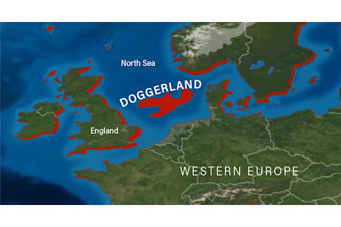
What is now the North Sea was land during much of prehistory. As the last glacial retreat began some 18,000 years ago, water slowly inundated this area, known as Doggerland. Rising sea levels shrank the area first to a peninsula, then an island, before flooding it completely. (Credit: Deep Time Maps/Alison Mackey/Discover)
Deep Time Maps/Alison Mackey/Discover
Look at a map of today’s Europe and its northern epicenters of population and commerce: London, Paris, Amsterdam, Copenhagen. Now consider that these hubs were once hinterland, mere fringes of an expanse rich in conifer forests, meadows, rivers and wetlands, all of it teeming with game. Prehistoric travelers could have walked from what’s now central Europe to northern Scotland without even seeing a coastline.
As the massive glaciers and ice sheets of the last ice age began melting about 18,000 years ago, rising seas inundated this world. The North Sea was born.
The submerged landmass, stretching between the coasts of today’s British Isles, Scandinavia, Germany and France, is known as Doggerland. It’s named for Dogger Bank, a productive fishing area on its northern edge.
“Doggerland is one of the most important pieces of landscape now submerged,” says University of York archaeologist Geoff Bailey who, while not directly involved in current Doggerland research, has followed his colleagues’ work with enthusiasm. “We know fauna [was] there by the ton. . . . It was a fantastic landscape with freshwater lakes and an abundance of food, immensely productive.”
Today, fishing boats crisscrossing the North Sea occasionally harvest clues to the lost land: mammoth tusks, weapons, tools and even skull fragments of humans and Neanderthals. During a period when humans were expanding north and agriculture was replacing hunting and foraging, Doggerland was a crossroads for different cultures. It also appears to have had some kind of trade network.
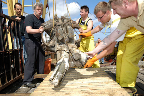
A mammoth skull caught in a Dutch skipper’s fishing net (pictures) and a 13,500-year-old decorated bison bone retrieved from the North Sea provide evidence that these animals resided there at a time when sea levels were much lower. (Credit: Wim Van Vossen)
Wim Van Vossen
For example, researchers have traced stone artifacts found all over Europe back to now-submerged rock outcrops, suggesting that the material was transported by humans throughout and beyond Doggerland.
“You would have had a landscape that would have facilitated communication and cultural exchange between what now are separate bits of land,” Bailey says.
Europe’s Lost Frontiers, a five-year project that will wrap up in 2020, has been exploring Doggerland on an unprecedented fine scale, mapping extinct rivers and identifying areas where human habitation was most likely. Multiple core samples are being analyzed to re-create lost paleoenvironments.
For example, a 2017 report by part of the Lost Frontiers team, published by the Micropaleontological Society, described multiple species of beetle in a Doggerland core. Based on the insects’ habitat and preferred food, and pollen also retrieved from the sample, the site may have been woodland, with large herbivores present — one of the beetle species found fed on their dung.
The core sample hinted at how the site changed over time, from a forest of Scots pine and hazel to one of oak and some elm. Ultimately, the presence of microorganisms that thrive in brackish water are witness to the landscape’s inundation.
Gemma Tarlach is senior editor at Discover. This article originally appeared in print as "Return to Aquaterra."


