With unusual heat refusing to loosen its grip on Western Canada, ten out-of-control wildfires are now burning in northern Alberta.
Thanks to the hot, dry weather and rising winds, officials in Alberta were concerned on Tuesday (May 29) that the Chuckegg Creek fire near High Level, Alberta could lead to “blow-up fire behavior.” The fire has already scorched 580 square miles — an area larger than the City of Los Angeles.
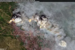
The Chuckegg Creek fire is seen in the satellite image above, captured by the Sentinel-2A satellite on May, 26, 2019. The image was processed by blogger and remote sensing expert Pierre Markuse.
The image combines natural color with data acquired in the infrared portion of the electromagnetic spectrum. The infrared reveals heat from the flames, which might otherwise be difficult to see through the smoke.
The image also reveals exploding columns of smoke. These have formed as rising air ...


