At Galchhi, Nepal’s Trishuli River climbed as much as 30 feet in just half an hour on August 26, 2026, according to the International Centre for Integrated Mountain Development (ICIMOD). The surge carried mud and boulders into communities along the river system.
The flood originated in Langtang National Park near Nepal’s border with Tibet, where a section of rock and glacier ice collapsed. Researchers later found that part of the slope had been picking up speed for weeks. Nature reported that the change was visible in satellite radar data, but it was not enough to tell researchers when the slope would fail.
By September 3, 2026, the disaster had killed at least 1,252 people in Nepal and left more than 4,200 missing, according to the Associated Press. While officials work to determine exactly how it began, a separate study published in Global and Planetary Change found that Langtang’s glaciers have been shrinking, thinning, and breaking into smaller pieces for generations.
Radar Detected Movement Before Nepal Glacier Collapse
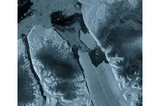
Virginia Tech geophysicist Manoochehr Shirzaei analyzed radar observations collected by the European Space Agency’s Sentinel-1 satellites, according to Nature. The measurements covered January 8, 2026 through August 18, 2026.
Unlike an ordinary satellite photograph, radar can measure changes in position that are far too small to see by eye. Each pass sends a radar signal toward the surface and records the signal that returns. By comparing measurements taken over the same location on different dates, researchers can calculate how the surface shifted and build a timeline of its movement.

 Explore All Options
The record showed downhill movement of about 0.4 inches (10 millimeters) per month near the part of the slope that later collapsed. Movement at that rate does not necessarily mean a slope is close to failing. As Shirzaei compared successive measurements, however, the rock and ice appeared to be moving faster.
The satellites were not continuously monitoring the slope, and the final observation was made about a week before the collapse. Shirzaei told Nature that the acceleration alone could not show whether a failure was imminent. The change became clear when he examined the record after the disaster, but similar measurements could help researchers determine which slopes deserve closer attention.
Read More: Typhoon Flooding in China Sends Farmed Venomous Snakes Swimming Into Residential Areas
Rock, Ice, and a River Rising by the Minute
According to the U.S. Geological Survey (USGS), the collapse released energy comparable to that of a 5.2-magnitude earthquake. The resulting debris and floodwater traveled nearly 62 miles through Lende Khola and into the Bhote Koshi and Trishuli rivers.
The agency has not determined whether rock broke away first and carried glacier ice downhill or whether the glacier gave way first and destabilized the surrounding rock.
Several river-monitoring stations were damaged or washed away, ICIMOD reported. Researchers are also investigating whether debris briefly blocked a narrow section of the river, allowing water to build before it escaped downstream.
A Glacier Landscape Breaking Apart
The Global and Planetary Change study reconstructed glacier conditions across the Langtang Catchment from around 1815 through 2023. Researchers found that the region lost approximately 41.5 percent of its glacier area during that period.
Yet the number of individual glaciers rose from 58 to 115. There were more glaciers to count because larger ones had broken into smaller pieces, not because the region had gained ice.
ICIMOD has cautioned that it is still too early to determine the extent to which climate change played a role in this particular disaster. The glacier study looks back nearly two centuries, while the radar observations cover the months leading up to one slope's collapse; researchers do not yet know whether the two are connected.
Read More: Ancient Corals Reveal Today's El Niños Are the Strongest in 1,000 Years
Article Sources
Our writers at Discovermagazine.com use peer-reviewed studies and high-quality sources for our articles, and our editors review for scientific accuracy and editorial standards. Review the sources used below for this article:
- This article references information from Nature: Satellite images before Nepal disaster showed warning signs
- This article references information from the USGS: 2026 Nepal Debris Avalanche and Flash Flood
- This article references information from ICIMOD: Major flash flood sweeps through Nepal’s Rasuwa district, raising fears of further downstream flooding
- This article references information from Global and Planetary Change: Glacier changes in Langtang Catchment, Central Nepalese Himalaya from the Little Ice Age (∼1815 CE) to 2023 CE
- This article references information from the AP: Trading food for medicine and crossing the river by zip line are part of life in Nepal flood zone